|
search place name
|
||
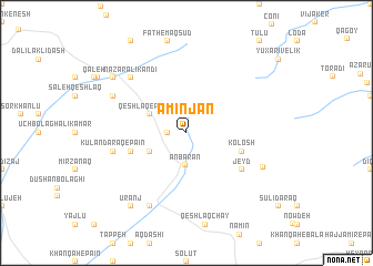
Amīn Jān (Kermān, Iran)Amīn Jān is a town in the Kermān region of Iran. An overview map of the region around Amīn Jān is displayed below.
regional and 3d topo map of Amīn Jān, Iran ::
Amīn Jān airports ::
The nearest airport is RAS - Rasht, located 167.7 km south east of Amīn Jān.
Other airports nearby include BAK - Baku Heydar Aliyev (257.2 km north east), Nearby towns ::
Qeshlāq-e Sarābād (1.5km west) //
‘Anbarān (3.2km south) //
Qeshlāq-e Pīlāz̄īr (3.4km north west) //
‘Anbarān-e Bālā (3.4km south west) //
Kolosh (4.7km south east) //
Kūlān Daraq-e Bālā (4.7km south west) //
‘Anbarān-e Pāʼīn (4.7km south west) //
Jeyd (5.7km south east) //
Tappeh Khvor (5.7km south east) //
Kūlān Daraq-e Pā'īn (6.1km west) //
Naz̧ar ‘Alī Kandī (7.1km north west) //
Hoshneh (7.1km north west) //
Pīr Javād (6.9km north west) //
Gerdeh (8.0km south) //
Golshan (6.9km south east) //
Masjed Maḩallehsī (8.0km north west) //
Khvoshābād (8.0km north west) //
Ūranj (8.6km south west) //
[all distances 'as the bird flies' and approximate] 
Disclaimer :: Information on this page comes without warranty of any kind |
||
|
Where is Amīn Jān? Elevation and coordinates ::
Latitude (lat): 38°31'0"N Longitude (lon): 48°26'0"E
Elevation (approx.): 1633m (map arrows pan, magnifying glasses zoom) |
||
|
Visiting Amīn Jān? Hotel/Accommodation ::
Book a hotel in Amīn Jān Travel Guide ::
Buy a travel guide for Iran rental cars ::
car rental offers GPS waypoint ::
download a GPX waypoint (PoI) of Amīn Jān for your GPS receiver
|
||