|
search place name
|
||
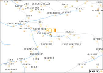
Ātīnī (Iran)Ātīnī is a town in Iran. An overview map of the region around Ātīnī is displayed below.
regional and 3d topo map of Ātīnī, Iran ::
Nearby towns ::
Qal‘eh Kūtī (1.9km south) //
Savā Sareh (2.4km north west) //
Tīlek (2.3km east) //
Gol Khvārān (2.6km west) //
Sīāh Gāvsar (4.0km south) //
Āghūz Galleh (4.0km north) //
Sīāvash Kolā (4.8km north west) //
Pā'īn Deh (4.5km east) //
Qal‘eh (4.5km east) //
Rūdbār (4.9km west) //
Īlāl (5.4km north west) //
Band-e Bon (5.7km south west) //
Bālā Deh (5.4km east) //
Chahār Rūdbār (5.9km west) //
Jamāl od Dīn Kolā (7.8km north) //
Gol Bāgh (6.7km north west) //
Tīleh Bon (6.6km east) //
Emāmzādeh Ebrāhīm (7.0km south east) //
Rūdbārak (8.8km south) //
Mīlad Dasht (7.7km north west) //
Qal‘eh Gardan (8.7km south west) //
Emāmzādeh ‘Alī (8.2km south west) //
Langar (9.2km north east) //
Senām (9.5km north west) //
[all distances 'as the bird flies' and approximate] 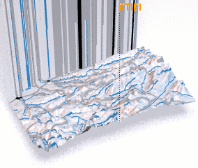 Places with similar names to Ātīnī, Iran ::
Disclaimer :: Information on this page comes without warranty of any kind |
||
|
Where is Ātīnī? Elevation and coordinates ::
Latitude (lat): 36°8'0"N Longitude (lon): 53°34'0"E
Elevation (approx.): 1517m (map arrows pan, magnifying glasses zoom) |
||
|
Visiting Ātīnī? Hotel/Accommodation ::
Book a hotel in Ātīnī Travel Guide ::
Buy a travel guide for Iran rental cars ::
car rental offers GPS waypoint ::
download a GPX waypoint (PoI) of Ātīnī for your GPS receiver
|
||