|
search place name
|
||
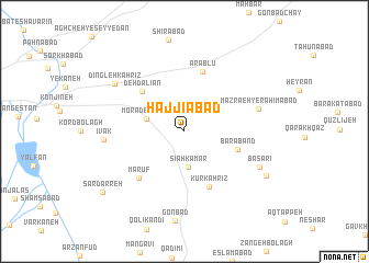
Ḩājjīābād (Hamadān, Iran)Ḩājjīābād is a town in the Hamadān region of Iran. An overview map of the region around Ḩājjīābād is displayed below.
regional and 3d topo map of Ḩājjīābād, Iran ::
Ḩājjīābād airports ::
The nearest airport is KSH - Bakhtaran Shahid Ashrafi Esfahani, located 153.2 km west of Ḩājjīābād.
Other airports nearby include SDG - Sanandaj (167.4 km west), Nearby towns ::
Sīāh Kamar (3.7km south) //
Morād Bolāghī (3.4km north west) //
Pol Shekasteh (3.7km north west) //
Bārāband (4.8km east) //
Deh Dalīān (5.4km north west) //
Kūr Kahrīz (6.1km south) //
‘Arablū (6.3km north) //
Ma‘rūf (6.0km south west) //
Mazra‘eh-ye Raḩīmābād (6.6km east) //
Īvak (6.8km west) //
Başarī (7.3km south east) //
Ābhendū (7.3km south east) //
Dīngleh Kahrīz (7.6km north west) //
Qeshlāq-e Āb Hendū (8.2km south east) //
Sar Darreh (9.2km south west) //
[all distances 'as the bird flies' and approximate]  Places with similar names to Ḩājjīābād, Iran ::
Disclaimer :: Information on this page comes without warranty of any kind |
||
|
Where is Ḩājjīābād? Elevation and coordinates ::
Latitude (lat): 34°45'59"N Longitude (lon): 48°44'53"E
Elevation (approx.): 1978m (map arrows pan, magnifying glasses zoom) |
||
|
Visiting Ḩājjīābād? Hotel/Accommodation ::
Book a hotel in Ḩājjīābād Travel Guide ::
Buy a travel guide for Iran rental cars ::
car rental offers GPS waypoint ::
download a GPX waypoint (PoI) of Ḩājjīābād for your GPS receiver
|
||