|
search place name
|
||
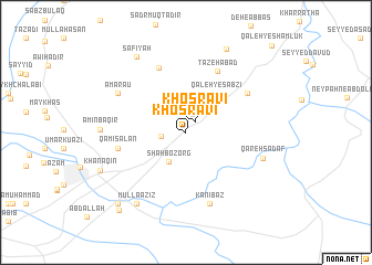
Khosravī (Iran)Khosravī is a town in Iran. An overview map of the region around Khosravī is displayed below.
regional and 3d topo map of Khosravī, Iran ::
Khosravī airports ::
The nearest airport is KSH - Bakhtaran Shahid Ashrafi Esfahani, located 154.6 km east of Khosravī.
Other airports nearby include SDG - Sanandaj (169.8 km north east), Nearby towns ::
Khosravī (1.3km north east) //
Valāyat-e Koshteh (2.1km west) //
Shāh Bozorg (3.3km south west) //
Qal‘eh-ye Sabzī (4.6km north east) //
Qāmī Salān (5.9km west) //
Tāzehābād (6.8km north east) //
Darband Jūq (6.9km north) //
Khar-e Nāşer Khān (6.4km north east) //
Kānī Baz (7.4km south) //
Amarau (6.9km north west) //
Qareh Şadaf (7.0km east) //
Qareh Şadaf (7.0km east) //
Amīn Bāqir (7.2km west) //
Mullā ‘Azīz (8.3km south west) //
Şafīyah (8.7km north west) //
Borj-e Aḩmadī (9.1km north) //
Khānaqīn (8.1km south west) //
Alwand (9.1km south west) //
Bānmīl (9.7km south west) //
Qal‘eh-ye Shāmlūk (11.3km north east) //
[all distances 'as the bird flies' and approximate]  Places with similar names to Khosravī, Iran ::
Disclaimer :: Information on this page comes without warranty of any kind |
||
|
Where is Khosravī? Elevation and coordinates ::
Latitude (lat): 34°22'52"N Longitude (lon): 45°28'41"E
Elevation (approx.): 261m (map arrows pan, magnifying glasses zoom) |
||
|
Visiting Khosravī? Hotel/Accommodation ::
Book a hotel in Khosravī Travel Guide ::
Buy a travel guide for Iran rental cars ::
car rental offers GPS waypoint ::
download a GPX waypoint (PoI) of Khosravī for your GPS receiver
|
||