|
search place name
|
||
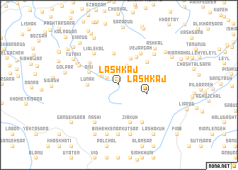
Lashkaj (Gīlān, Iran)Lashkaj is a town in the Gīlān region of Iran. An overview map of the region around Lashkaj is displayed below.
regional and 3d topo map of Lashkaj, Iran ::
Lashkaj airports ::
The nearest airport is RAS - Rasht, located 43.3 km north west of Lashkaj.
Other airports nearby include RZR - Ramsar (67.9 km east), THR - Teheran Mehrabad Intl (194.2 km south east), Nearby towns ::
Pīleh Sarā (0.8km north) //
Lūshā Deh (1.9km north west) //
Dolākeshān (2.7km north) //
Bālā Rūd (2.5km north west) //
Deh Jūn (3.1km north) //
Bījār Sarā (2.9km north west) //
Sīzkūh (4.3km north) //
Lashkaj (3.8km east) //
Lūnak (3.9km west) //
Poltūrū Dasht (5.0km north) //
Nīsī (4.3km north west) //
Līshomeh (4.9km north east) //
Nīach (5.0km north east) //
Gālesh Zamīn (5.0km north west) //
Vejārgāh (5.7km north east) //
Ẕīā' Kūh (6.1km south) //
Līālekal (5.8km north west) //
Āsū (5.9km north west) //
Tūsā Posht (6.6km south east) //
Dashtān (6.7km south west) //
Nāshī (6.7km south west) //
Khormā (6.5km north east) //
Angolbar (6.3km north west) //
Dārānbārī (7.8km south) //
Kachal Bon (7.9km south) //
Kūt Sar (7.9km south) //
Bīsheh Kenār (8.0km south) //
Ashkāl (7.4km north east) //
Tūtakī (7.0km north west) //
[all distances 'as the bird flies' and approximate]  Places with similar names to Lashkaj, Iran ::
// Lashkaj (IR)
Disclaimer :: Information on this page comes without warranty of any kind |
||
|
Where is Lashkaj? Elevation and coordinates ::
Latitude (lat): 37°2'13"N Longitude (lon): 49°56'2"E
Elevation (approx.): 477m (map arrows pan, magnifying glasses zoom) |
||
|
Visiting Lashkaj? Hotel/Accommodation ::
Book a hotel in Lashkaj Travel Guide ::
Buy a travel guide for Iran rental cars ::
car rental offers GPS waypoint ::
download a GPX waypoint (PoI) of Lashkaj for your GPS receiver
|
||