|
search place name
|
||
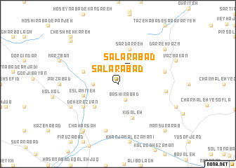
Sālārābād (Ostān-e Kermānshāh, Iran)Sālārābād is a town in the Ostān-e Kermānshāh region of Iran. An overview map of the region around Sālārābād is displayed below.
regional and 3d topo map of Sālārābād, Iran ::
Sālārābād airports ::
The nearest airport is SDG - Sanandaj, located 61.7 km north west of Sālārābād.
Other airports nearby include KSH - Bakhtaran Shahid Ashrafi Esfahani (83.9 km south west), Nearby towns ::
Sālārābād (2.4km north east) //
Bashīrābād (2.6km south) //
Gerdkānī-ye Soflá (3.2km west) //
Gūr-e Yahūd (4.8km south west) //
Kīsaleh (5.6km south) //
Sar Darreh (5.8km north) //
Eslāmīyeh (4.9km west) //
Kelak (4.9km west) //
Āsīāb Jūb-e Farmānfarmā (4.9km west) //
Deh-e Reẕvān (5.9km south west) //
Baghdād Shāh (5.9km south west) //
Meykhvārān-e Farmānfarmā (6.3km east) //
Cham Kabūd (7.6km south) //
Meykhvorān-e Moḩammad Āqā (6.4km east) //
Charkas (7.1km south west) //
Darreh Vazm (8.2km north east) //
Chahārgāh (8.7km south west) //
Meydān (9.0km south west) //
Gerdkānī-ye ‘Olyā (9.2km north west) //
Manşūr ‘Arab (9.6km south east) //
Cheshmeh Kareh (9.6km north west) //
[all distances 'as the bird flies' and approximate]  Places with similar names to Sālārābād, Iran ::
Disclaimer :: Information on this page comes without warranty of any kind |
||
|
Where is Sālārābād? Elevation and coordinates ::
Latitude (lat): 35°0'0"N Longitude (lon): 47°37'0"E
Elevation (approx.): 2013m (map arrows pan, magnifying glasses zoom) |
||
|
Visiting Sālārābād? Hotel/Accommodation ::
Book a hotel in Sālārābād Travel Guide ::
Buy a travel guide for Iran rental cars ::
car rental offers GPS waypoint ::
download a GPX waypoint (PoI) of Sālārābād for your GPS receiver
|
||