|
search place name
|
||
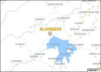
Aliviadero (Zulia, Venezuela)Aliviadero is a town in the Zulia region of Venezuela. An overview map of the region around Aliviadero is displayed below.
regional and 3d topo map of Aliviadero, Venezuela ::
Aliviadero airports ::
The nearest airport is MAR - Maracaibo La Chinita Intl, located 62.5 km south east of Aliviadero.
Other airports nearby include RCH - Rio Hacha Almirante Padilla (106.6 km north west), VUP - Valledupar Alfonso Lopez Pumarejo (130.1 km south west), STB - Santa Barbara Del Zulia (216.6 km south), VLV - Valera Dr Antonio Nicolas Briceno (246.2 km south east), Nearby towns ::
Los Patos (4.5km south east) //
Valencia (6.3km north west) //
La Cazadora (7.1km east) //
Las Parcelas de Manuelote (7.3km north west) //
Playa Bonita (7.4km north east) //
Manuelote (8.0km north west) //
Tule (8.4km south east) //
Río Cachirí (8.6km south west) //
Tamaral (9.4km south east) //
El Ceibote (9.6km south east) //
Rancho L (10.5km south west) //
[all distances 'as the bird flies' and approximate]  Places with similar names to Aliviadero, Venezuela ::
// Al Ghādūrī (IQ)
// Alfatar (BG)
// Al Ghaddārah (LY)
// Aliviadero (VE)
// Al Faţīrah (SY)
// Al ‘Afādirah (EG)
// Al Fīdār (LB)
// Alfter (DE)
// Al Ghadīr (YE)
// Al Ghadīr (YE)
Disclaimer :: Information on this page comes without warranty of any kind |
||
|
Where is Aliviadero? Elevation and coordinates ::
Latitude (lat): 10°55'14"N Longitude (lon): 72°10'0"W
Elevation (approx.): 31m (map arrows pan, magnifying glasses zoom) |
||
|
Visiting Aliviadero? Hotel/Accommodation ::
Book a hotel in Aliviadero Travel Guide ::
Buy a travel guide for Venezuela rental cars ::
car rental offers GPS waypoint ::
download a GPX waypoint (PoI) of Aliviadero for your GPS receiver
|
||