|
search place name
|
||
Los Caballos (Sucre, Venezuela)Los Caballos is a town in the Sucre region of Venezuela. An overview map of the region around Los Caballos is displayed below.
regional and 3d topo map of Los Caballos, Venezuela ::

Los Caballos airports ::
The nearest airport is GUI - Guiria, located 52.7 km east of Los Caballos.
Other airports nearby include CUP - Carupano General Jose Francisco Bermudez (54.7 km west), MUN - Maturin (116.7 km south), PMV - Porlamar Del Caribe Intl Gen Santiago Marino (132.8 km west), CUM - Cumana Antonio Jose De Sucre (152.5 km west), Nearby towns ::
Cumbre de Caballo (1.0km south east) //
Tigrillo (1.6km west) //
Cumbre de Tigrillo (2.3km south west) //
San Juan de Unare (2.9km east) //
Macanillal (3.7km south east) //
Cumbre de las Flores (4.0km east) //
Guarataro (4.1km west) //
Unare (4.2km north east) //
Cumbre Fria (4.6km south) //
Buena Vista (4.7km south west) //
La Florida (5.3km south) //
Catuchal (6.0km south west) //
La Guama (6.2km south west) //
Guacuco (6.2km west) //
La Florida (6.5km south) //
Buenos Aires (6.9km south) //
El Cedro (7.4km south east) //
El Saco (7.7km south west) //
San Agustín (7.9km south east) //
Cipara (7.8km east) //
La Palmera (8.0km south west) //
Cayena (8.1km east) //
El Bajo (8.2km south west) //
San Juan de las Galdonas (8.4km west) //
La Florida (8.6km south east) //
El Brasil (8.7km south east) //
El Cobre (9.3km south east) //
Las Clavellinas (9.5km south west) //
Las Catanas (9.6km south west) //
[all distances 'as the bird flies' and approximate] 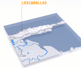 Places with similar names to Los Caballos, Venezuela ::
// Las Caobillas (CU)
// Las Cábilas (ES)
// Los Caballos (CO)
// Los Caballos (CO)
// Los Caballos (CO)
// Los Caballos (MX)
// Los Caballos (MX)
// Los Caballos (MX)
// Los Caballos (MX)
// Los Caballos (MX)
Disclaimer :: Information on this page comes without warranty of any kind |
||
|
Where is Los Caballos? Elevation and coordinates ::
Latitude (lat): 10°43'56"N Longitude (lon): 62°46'0"W
Elevation (approx.): 138m (map arrows pan, magnifying glasses zoom) |
||
|
Visiting Los Caballos? Hotel/Accommodation ::
Book a hotel in Los Caballos Travel Guide ::
Buy a travel guide for Venezuela rental cars ::
car rental offers GPS waypoint ::
download a GPX waypoint (PoI) of Los Caballos for your GPS receiver
|
||