|
search place name
|
||
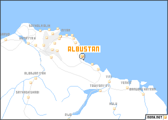
Al Bustān (Masqaţ, Oman)Al Bustān is a town in the Masqaţ region of Oman. An overview map of the region around Al Bustān is displayed below.
regional and 3d topo map of Al Bustān, Oman ::
Al Bustān airports ::
The nearest airport is MCT - Muscat Seeb Intl, located 33.7 km west of Al Bustān.
Other airports nearby include ZBR - Chah Bahar (274.2 km north east), Nearby towns ::
Qantab (1.9km south east) //
Haramil (2.9km north west) //
Sidāb (3.4km north west) //
Bandar Jişşah (3.6km south east) //
Ţawiyān (4.2km north west) //
Masqaţ (5.3km north west) //
Kalbūh (6.1km north west) //
Wādī Kabīr (5.8km west) //
Riyām (6.6km north west) //
Maţraḩ (6.9km north west) //
Ḩamrīyah (6.7km west) //
Muţayraḩ (7.1km north west) //
Dikkah (7.1km north west) //
Yiţī (7.1km south east) //
Ruwī (6.9km west) //
Bayt al Falaj (7.1km north west) //
Ţawiyān Yiţī (7.6km south east) //
Ash Shuţayfī (8.8km north west) //
Sūraj (8.7km north west) //
Dārsayt ‘Alwā (9.1km north west) //
Dārsayt (9.9km north west) //
[all distances 'as the bird flies' and approximate] 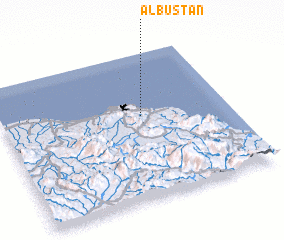 Places with similar names to Al Bustān, Oman ::
// Al Basātīn (EG)
// Al Basātīn (EG)
// Al Bustān (EG)
// Al Bustān (TN)
// Al Bustān (SA)
// Al Bustān (SY)
// Al Bustān (SY)
// Al Bustān (SY)
// Albouystown (GY)
// Al Basātīn (LB)
Disclaimer :: Information on this page comes without warranty of any kind |
||
|
Where is Al Bustān? Elevation and coordinates ::
Latitude (lat): 23°34'12"N Longitude (lon): 58°36'50"E
Elevation (approx.): -32768m (map arrows pan, magnifying glasses zoom) |
||
|
Visiting Al Bustān? Hotel/Accommodation ::
Book a hotel in Al Bustān Travel Guide ::
Buy a travel guide for Oman rental cars ::
car rental offers GPS waypoint ::
download a GPX waypoint (PoI) of Al Bustān for your GPS receiver
|
||