|
search place name
|
||
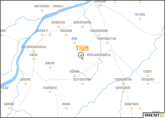
Tium (Gongola, Nigeria)Tium is a town in the Gongola region of Nigeria. An overview map of the region around Tium is displayed below.
regional and 3d topo map of Tium, Nigeria ::
Tium airports ::
The nearest airport is KAN - Kano Mallam Aminu Intl, located 174.3 km north west of Tium.
Other airports nearby include JOS - Jos Yakubu Gowon (200.1 km south west), Nearby towns ::
Bajala (0.0km north) //
Kwajela (0.0km north) //
Anguwan Gariji (3.6km east) //
Aru (4.1km north west) //
Rumba (4.1km south west) //
Dutsen Kam (5.6km south) //
Nakawa (6.6km north west) //
Nassarawa (6.6km north east) //
Farin Dutse (6.6km north east) //
Samongara (7.4km north) //
Baima (7.5km west) //
Gabanga (9.2km north west) //
Babaa (9.2km north west) //
Ruwa Uku (10.4km south west) //
[all distances 'as the bird flies' and approximate] 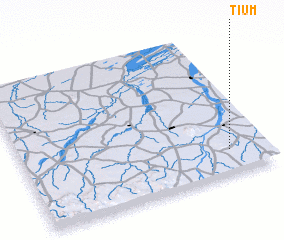 Places with similar names to Tium, Nigeria ::
Disclaimer :: Information on this page comes without warranty of any kind |
||
|
Where is Tium? Elevation and coordinates ::
Latitude (lat): 11°10'0"N Longitude (lon): 9°51'0"E
Elevation (approx.): 473m (map arrows pan, magnifying glasses zoom) |
||
|
Visiting Tium? Hotel/Accommodation ::
Book a hotel in Tium Travel Guide ::
Buy a travel guide for Nigeria rental cars ::
car rental offers GPS waypoint ::
download a GPX waypoint (PoI) of Tium for your GPS receiver
|
||