|
search place name
|
||
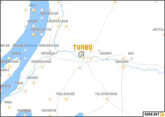
Tumbo (Gongola, Nigeria)Tumbo is a town in the Gongola region of Nigeria. An overview map of the region around Tumbo is displayed below.
regional and 3d topo map of Tumbo, Nigeria ::
Tumbo airports ::
The nearest airport is SKO - Sokoto Sadiq Abubakar Iii Intl, located 119.7 km east of Tumbo.
Other airports nearby include NIM - Niamey Diori Hamani (214.1 km west), THZ - Tahoua (225.2 km north east), Nearby towns ::
Tungan Chafa (0.0km north) //
Kitakite (1.9km north) //
Kita Kité (1.9km north) //
Share Bachaka (1.8km east) //
Tombon Bouya (2.2km south) //
Malabawa (2.6km north west) //
Kalume (2.6km north east) //
Angwa Sarkin (4.1km north east) //
Kumare (5.4km east) //
Botawa (5.4km east) //
Sèrmakoy (7.2km west) //
Bangarassa (7.5km west) //
Angoal Mayaki (7.5km west) //
Doumani (8.2km north west) //
Garin Sékaro (9.2km north west) //
[all distances 'as the bird flies' and approximate] 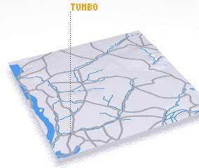 Places with similar names to Tumbo, Nigeria ::
Disclaimer :: Information on this page comes without warranty of any kind |
||
|
Where is Tumbo? Elevation and coordinates ::
Latitude (lat): 13°10'0"N Longitude (lon): 4°8'0"E
Elevation (approx.): 214m (map arrows pan, magnifying glasses zoom) |
||
|
Visiting Tumbo? Hotel/Accommodation ::
Book a hotel in Tumbo Travel Guide ::
Buy a travel guide for Nigeria rental cars ::
car rental offers GPS waypoint ::
download a GPX waypoint (PoI) of Tumbo for your GPS receiver
|
||