|
search place name
|
||
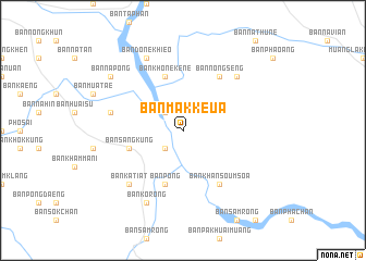
Ban Mak Keua (Laos)Ban Mak Keua is a town in Laos. An overview map of the region around Ban Mak Keua is displayed below.
regional and 3d topo map of Ban Mak Keua, Laos ::
Ban Mak Keua airports ::
The nearest airport is PKZ - Pakse, located 87.7 km south east of Ban Mak Keua.
Other airports nearby include ZVK - Savannakhet (105.3 km north west), SNO - Sakon Nakhon (203.5 km north west), Nearby towns ::
Ban Song Khon (2.6km south west) //
Ban Pak Huai (2.6km north west) //
Ban Sang Kung (5.7km west) //
Ban Pong (5.8km south) //
Ban Khône Kène (5.8km north) //
Ban Khan Soum Soa (6.6km south east) //
Ban Nong Seng (6.6km north east) //
Ban Don Chat (7.4km west) //
Ban Nakala (7.7km north east) //
Ban Katiat (7.7km south west) //
Ban Ko Rong (8.2km south west) //
Ban Done Khieo (8.2km north west) //
Ban Na Pong (9.0km north west) //
[all distances 'as the bird flies' and approximate]  Places with similar names to Ban Mak Keua, Laos ::
// Ban Mae Ka (TH)
// Ban Mae Kae (TH)
// Ban Mae Ki (TH)
// Ban Mae Kua (TH)
// Ban Mae Ok (TH)
// Ban Mai (2) (TH)
// Ban Mai (2) (TH)
// Ban Mai (2) (TH)
// Ban Mai (2) (TH)
// Ban Mai (2) (TH)
Disclaimer :: Information on this page comes without warranty of any kind |
||
|
Where is Ban Mak Keua? Elevation and coordinates ::
Latitude (lat): 15°50'0"N Longitude (lon): 105°24'0"E
Elevation (approx.): 130m (map arrows pan, magnifying glasses zoom) |
||
|
Visiting Ban Mak Keua? Hotel/Accommodation ::
Book a hotel in Ban Mak Keua Travel Guide ::
Buy a travel guide for Laos rental cars ::
car rental offers GPS waypoint ::
download a GPX waypoint (PoI) of Ban Mak Keua for your GPS receiver
|
||