|
search place name
|
||
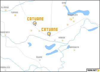
Catuane (Maputo, Mozambique)Catuane is a town in the Maputo region of Mozambique. An overview map of the region around Catuane is displayed below.
regional and 3d topo map of Catuane, Mozambique ::
Catuane airports ::
The nearest airport is MTS - Manzini Matsapha, located 103.0 km west of Catuane.
Other airports nearby include MPM - Maputo (105.4 km north), ULD - Ulundi Prince Mangosuthu Buthelezi (185.5 km south west), RCB - Richard's Bay Richards Bay (211.9 km south), SZK - Skukuza (219.2 km north), Nearby towns ::
Komankobolo (2.2km south east) //
Cuca (4.1km north west) //
Mabisa (4.5km east) //
Catuane (6.2km north west) //
Tomaz (6.6km west) //
Nozoagala (7.3km north east) //
Chefe P. Tembe (9.3km north east) //
Bebelhane (9.3km north east) //
Muguelha (10.3km north east) //
[all distances 'as the bird flies' and approximate] 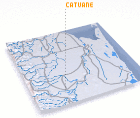 Places with similar names to Catuane, Mozambique ::
Disclaimer :: Information on this page comes without warranty of any kind |
||
|
Where is Catuane? Elevation and coordinates ::
Latitude (lat): 26°50'11"S Longitude (lon): 32°17'4"E
Elevation (approx.): 44m (map arrows pan, magnifying glasses zoom) |
||
|
Visiting Catuane? Hotel/Accommodation ::
Book a hotel in Catuane Travel Guide ::
Buy a travel guide for Mozambique rental cars ::
car rental offers GPS waypoint ::
download a GPX waypoint (PoI) of Catuane for your GPS receiver
|
||