|
search place name
|
||
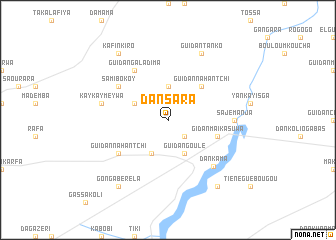
Dan Sara (Maradi, Niger)Dan Sara is a town in the Maradi region of Niger. An overview map of the region around Dan Sara is displayed below.
regional and 3d topo map of Dan Sara, Niger ::
Dan Sara airports ::
The nearest airport is MFG - Maradi, located 69.6 km west of Dan Sara.
Other airports nearby include ZND - Zinder (141.7 km east), KAN - Kano Mallam Aminu Intl (166.8 km south east), QUS - Gusau (173.5 km south west), Nearby towns ::
Guidan Chinao (2.6km south east) //
Guidan Makada (3.7km north) //
Dan Matyawa (4.1km south west) //
Guidan Goulé (4.1km south east) //
Guidan Kyata (4.1km north west) //
Guidan Nahantchi (5.2km north east) //
Gidan Maikasuwa (5.7km east) //
Guidan Nahantchi (6.6km south west) //
Guidan Doutchi (6.6km south west) //
Sami Bokoy (6.6km north west) //
Guidan Galadima (6.6km north west) //
Dankama (7.2km south east) //
Sajé Manja (7.2km east) //
Kaykay Meywa (7.4km west) //
Guidan Tanko (8.2km north east) //
Gonga Béréla (9.2km south west) //
Lalaini (9.2km south east) //
Kafin Kiro (9.2km north west) //
[all distances 'as the bird flies' and approximate] 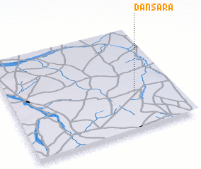 Places with similar names to Dan Sara, Niger ::
// Tanessar (MA)
// Da-an Sur (PH)
// Dinosaur (US)
// Duna Sor (HU)
// Tõnissaare (EE)
// Danışır (TR)
// Dansür (TR)
// Dansar (IR)
// Deh Naz̄rī (IR)
// Dīneh Sar (IR)
Disclaimer :: Information on this page comes without warranty of any kind |
||
|
Where is Dan Sara? Elevation and coordinates ::
Latitude (lat): 13°21'0"N Longitude (lon): 7°45'0"E
Elevation (approx.): 461m (map arrows pan, magnifying glasses zoom) |
||
|
Visiting Dan Sara? Hotel/Accommodation ::
Book a hotel in Dan Sara Travel Guide ::
Buy a travel guide for Niger rental cars ::
car rental offers GPS waypoint ::
download a GPX waypoint (PoI) of Dan Sara for your GPS receiver
|
||