|
search place name
|
||
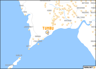
Tumbu (Western Area, Sierra Leone)Tumbu is a town in the Western Area region of Sierra Leone. An overview map of the region around Tumbu is displayed below.
regional and 3d topo map of Tumbu, Sierra Leone ::
Tumbu airports ::
The nearest airport is FNA - Freetown Lungi, located 45.4 km north of Tumbu.
Nearby towns ::
Tissana (1.9km north) //
Kissi Town (2.6km south west) //
Russel (4.1km north east) //
Mamah (4.1km south west) //
Jummu Town (4.3km north east) //
Bokari Town (4.6km north east) //
Kerry Town (4.7km north) //
Boma (4.7km north east) //
Timmani Town (4.9km north east) //
Mama Town (4.9km north east) //
Fodi Town (5.2km south west) //
Cline Town (5.5km north) //
Kebbie Town (5.9km north) //
Bure Town (5.9km west) //
Rocky (6.0km north east) //
Kerry Town (6.2km north) //
Mary Wharf (6.5km north east) //
Cole Town (6.6km north) //
Sattia Town (6.6km north east) //
Bwango Town (6.6km north east) //
New Fakai (6.9km north east) //
Battam Town (6.9km north east) //
Macdonald Wharf (7.3km north east) //
Kottopema (7.4km north east) //
Macdonald (7.5km north) //
John Obey (7.6km west) //
Kani (8.0km north east) //
Fakina (8.1km north) //
Baponto (8.1km north east) //
[all distances 'as the bird flies' and approximate]  Places with similar names to Tumbu, Sierra Leone ::
Disclaimer :: Information on this page comes without warranty of any kind |
||
|
Where is Tumbu? Elevation and coordinates ::
Latitude (lat): 8°13'0"N Longitude (lon): 13°6'0"W
Elevation (approx.): 30m (map arrows pan, magnifying glasses zoom) |
||
|
Visiting Tumbu? Hotel/Accommodation ::
Book a hotel in Tumbu Travel Guide ::
rental cars ::
car rental offers GPS waypoint ::
download a GPX waypoint (PoI) of Tumbu for your GPS receiver
|
||