|
search place name
|
||
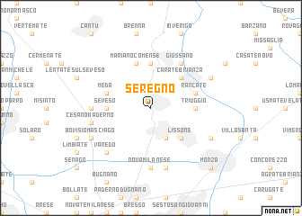
Seregno (Italy)Seregno is a town in Italy. An overview map of the region around Seregno is displayed below.
regional and 3d topo map of Seregno, Italy ::
Seregno airports ::
The nearest airport is LIN - Milan Linate, located 23.5 km south of Seregno.
Other airports nearby include MXP - Milano Malpensa (36.9 km west), BGY - Bergamo Orio Al Serio (39.4 km east), LUG - Lugano (45.3 km north west), QPZ - Piacenza (91.6 km south east), Nearby towns ::
Desio (3.9km south) //
Lissone (4.5km south east) //
Carate Brianza (4.5km north east) //
Seveso (3.9km west) //
Triuggio (3.9km east) //
Albiate (3.9km east) //
Arosio (5.6km north) //
Meda (4.3km north west) //
Rancate (4.3km north east) //
Mariano Comense (5.7km north) //
Robbiano (6.1km north east) //
Giussano (6.1km north east) //
Nova Milanese (7.4km south) //
Barlassina (5.2km west) //
Muggiò (7.5km south) //
Cesano Maderno (5.5km west) //
Varedo (6.8km south west) //
Bovisio Masciago (6.4km south west) //
Biassono (6.4km south east) //
Calò (6.4km north east) //
Monza (9.0km south east) //
[all distances 'as the bird flies' and approximate] 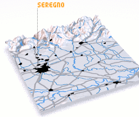 Places with similar names to Seregno, Italy ::
Disclaimer :: Information on this page comes without warranty of any kind |
||
|
Where is Seregno? Elevation and coordinates ::
Latitude (lat): 45°39'0"N Longitude (lon): 9°12'0"E
Elevation (approx.): 226m (map arrows pan, magnifying glasses zoom) |
||
|
Visiting Seregno? Hotel/Accommodation ::
Book a hotel in Seregno Travel Guide ::
Buy a travel guide for Italy rental cars ::
car rental offers GPS waypoint ::
download a GPX waypoint (PoI) of Seregno for your GPS receiver
|
||