|
search place name
|
||
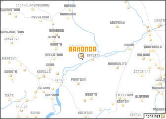
Bamonoa (Bomi, Liberia)Bamonoa is a town in the Bomi region of Liberia. An overview map of the region around Bamonoa is displayed below.
regional and 3d topo map of Bamonoa, Liberia ::
Bamonoa airports ::
The nearest airport is MLW - Monrovia Spriggs Payne, located 65.7 km south west of Bamonoa.
Other airports nearby include ROB - Monrovia Roberts Intl (68.5 km south), Nearby towns ::
Barota (2.2km east) //
Kaungba (2.4km north west) //
Fani Town (5.5km south) //
Bie Town Number One (6.5km south west) //
Mecca Town (6.5km west) //
Nobata (6.6km west) //
Danadi (7.6km south west) //
Nemata (7.7km north west) //
Geba (7.7km west) //
Momo Kolita (7.9km east) //
Bombomai (8.2km north west) //
Be Sato (8.9km south) //
Garu Town (9.5km south west) //
Bomboma (10.5km north west) //
Dokpoimu (10.7km north east) //
Gbesuma (11.3km south west) //
Baatown (12.0km south east) //
[all distances 'as the bird flies' and approximate] 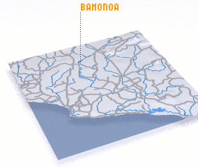 Places with similar names to Bamonoa, Liberia ::
Disclaimer :: Information on this page comes without warranty of any kind |
||
|
Where is Bamonoa? Elevation and coordinates ::
Latitude (lat): 6°49'58"N Longitude (lon): 10°31'11"W
Elevation (approx.): 110m (map arrows pan, magnifying glasses zoom) |
||
|
Visiting Bamonoa? Hotel/Accommodation ::
Book a hotel in Bamonoa Travel Guide ::
Buy a travel guide for Liberia rental cars ::
car rental offers GPS waypoint ::
download a GPX waypoint (PoI) of Bamonoa for your GPS receiver
|
||