|
search place name
|
||
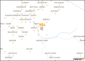
Háj (Slovakia)Háj is a town in Slovakia. An overview map of the region around Háj is displayed below.
regional and 3d topo map of Háj, Slovakia ::
Háj airports ::
The nearest airport is SLD - Sliac, located 31.4 km south east of Háj.
Other airports nearby include PZY - Piestany (82.1 km west), TAT - Poprad Tatry (102.0 km east), OSR - Ostrava Mosnov (108.0 km north west), PRV - Prerov (124.5 km north west), Nearby towns ::
Rakša (1.9km north) //
Turčianske Teplice (1.2km west) //
Turčiansky Svätý Michal (2.2km north west) //
Zorkovce (2.2km north west) //
Dolná Štubňa (2.2km south west) //
Čremošné (2.2km south east) //
Vieska (2.4km west) //
Diviaky (3.1km north west) //
Mošovce (3.9km north) //
Bodorová (4.4km north west) //
Horná Štubňa (5.6km south) //
Kevice (6.1km north west) //
Malý Čepčín (5.2km north west) //
Požehy (5.2km west) //
Blážovce (7.8km north) //
Bodovice (7.8km north) //
Borcová (7.8km north) //
Veľký Čepčín (6.1km north west) //
Jazernica (8.3km north west) //
Blatnica (8.3km north east) //
Ivančiná (7.4km north west) //
[all distances 'as the bird flies' and approximate] 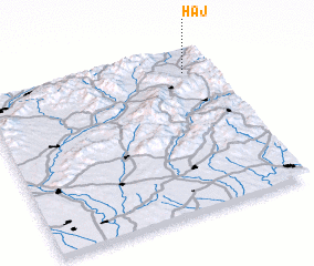 Places with similar names to Háj, Slovakia ::
Disclaimer :: Information on this page comes without warranty of any kind |
||
|
Where is Háj? Elevation and coordinates ::
Latitude (lat): 48°52'0"N Longitude (lon): 18°53'0"E
Elevation (approx.): 508m (map arrows pan, magnifying glasses zoom) |
||
|
Visiting Háj? Hotel/Accommodation ::
Book a hotel in Háj Travel Guide ::
Buy a travel guide for Slovakia rental cars ::
car rental offers GPS waypoint ::
download a GPX waypoint (PoI) of Háj for your GPS receiver
|
||