|
search place name
|
||
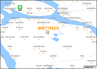
Brattåsen (Jämtland, Sweden)Brattåsen is a town in the Jämtland region of Sweden. An overview map of the region around Brattåsen is displayed below.
regional and 3d topo map of Brattåsen, Sweden ::
Brattåsen airports ::
The nearest airport is OSD - Ostersund Froson, located 11.6 km north west of Brattåsen.
Other airports nearby include EVG - Sveg (117.6 km south), Nearby towns ::
Södra Rasten (3.8km north) //
Bällsta (3.8km north) //
Gilleråsen (2.5km south west) //
Namn (5.6km north) //
Knytta (5.6km north) //
Norra Rasten (5.6km north) //
Sandviken (5.8km north) //
Slandrom (4.5km north east) //
Övre Måläng (5.8km south) //
Bleka (7.5km south) //
Böle (6.1km north west) //
Nedre Måläng (6.1km south west) //
Bledäng (7.6km south) //
Fillsta (6.5km north west) //
Odenslund (7.8km north) //
Lövsåsen (6.5km south east) //
Valla (8.1km north west) //
[all distances 'as the bird flies' and approximate]  Places with similar names to Brattåsen, Sweden ::
// Bretthausen (DE)
// Bretzin (DE)
// Bertesina (IT)
// Bierdzany (PL)
// Brudzeń (PL)
// Brudzyń (PL)
// Bartašiūnai (LT)
// Bardžūni (LV)
// Borduşani (RO)
// Borduşani (RO)
Disclaimer :: Information on this page comes without warranty of any kind |
||
|
Where is Brattåsen? Elevation and coordinates ::
Latitude (lat): 63°6'0"N Longitude (lon): 14°36'0"E
(map arrows pan, magnifying glasses zoom) |
||
|
Visiting Brattåsen? Hotel/Accommodation ::
Book a hotel in Brattåsen Travel Guide ::
Buy a travel guide for Sweden rental cars ::
car rental offers GPS waypoint ::
download a GPX waypoint (PoI) of Brattåsen for your GPS receiver
|
||