|
search place name
|
||
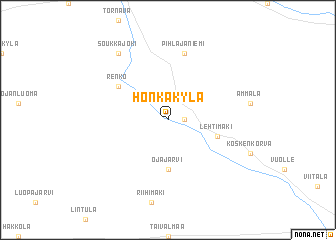
Honkakylä (Länsi-Suomen Lääni, Finland)Honkakylä is a town in the Länsi-Suomen Lääni region of Finland. An overview map of the region around Honkakylä is displayed below.
regional and 3d topo map of Honkakylä, Finland ::
Honkakylä airports ::
The nearest airport is KAU - Kauhava, located 52.0 km north of Honkakylä.
Other airports nearby include VAA - Vaasa (71.3 km north west), KOK - Kruunupyy (118.3 km north), KEV - Halli (133.9 km south east), TMP - Tampere Pirkkala (144.6 km south), Nearby towns ::
Kuivasaari (0.9km east) //
Ojajärvi (5.6km south) //
Lehtimäki (3.2km south east) //
Renko (4.5km north west) //
Pihlajaniemi (7.5km north) //
Soukkajoki (7.8km north) //
[all distances 'as the bird flies' and approximate] 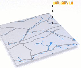 Places with similar names to Honkakylä, Finland ::
// Hinukgala (LK)
// Hanggae-gol (KP)
// Hongga-gol (KP)
// Hongŭi-gol (KP)
// Hung-k'u-liao (TW)
// Hongkeli (CN)
// Honkakylä (FI)
Disclaimer :: Information on this page comes without warranty of any kind |
||
|
Where is Honkakylä? Elevation and coordinates ::
Latitude (lat): 62°40'0"N Longitude (lon): 22°53'0"E
(map arrows pan, magnifying glasses zoom) |
||
|
Visiting Honkakylä? Hotel/Accommodation ::
Book a hotel in Honkakylä Travel Guide ::
Buy a travel guide for Finland rental cars ::
car rental offers GPS waypoint ::
download a GPX waypoint (PoI) of Honkakylä for your GPS receiver
|
||