|
search place name
|
||
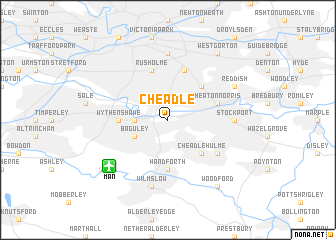
Cheadle (United Kingdom)Cheadle is a town in United Kingdom. An overview map of the region around Cheadle is displayed below.
regional and 3d topo map of Cheadle, United Kingdom ::
Cheadle airports ::
The nearest airport is MAN - Manchester, located 6.4 km south west of Cheadle.
Other airports nearby include LPL - Liverpool (42.8 km west), CEG - Hawarden (56.4 km south west), LBA - Leeds Bradford (63.6 km north east), BLK - Blackpool (67.8 km north west), Nearby towns ::
Northenden (2.2km west) //
Baguley (2.9km south west) //
Cheadle Hulme (4.3km south east) //
Heaton Chapel (4.3km north east) //
Handforth (5.6km south) //
Wythenshawe (3.3km west) //
Rusholme (5.7km north) //
Heaton Norris (3.8km north east) //
Levenshulme (5.7km north) //
Bramhall (5.0km south east) //
Chorlton upon Medlock (7.4km north) //
Stockport (4.4km east) //
Wilmslow (7.5km south) //
Reddish (5.8km north east) //
Ringway (7.1km south west) //
West Gorton (8.1km north east) //
Gorton (8.1km north east) //
Woodford (8.1km south east) //
Openshaw (8.1km north east) //
[all distances 'as the bird flies' and approximate] 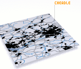 Places with similar names to Cheadle, United Kingdom ::
Disclaimer :: Information on this page comes without warranty of any kind |
||
|
Where is Cheadle? Elevation and coordinates ::
Latitude (lat): 53°24'0"N Longitude (lon): 2°13'0"W
Elevation (approx.): 41m (map arrows pan, magnifying glasses zoom) |
||
|
Visiting Cheadle? Hotel/Accommodation ::
Book a hotel in Cheadle Travel Guide ::
rental cars ::
car rental offers GPS waypoint ::
download a GPX waypoint (PoI) of Cheadle for your GPS receiver
|
||