|
search place name
|
||
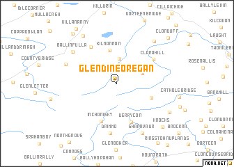
Glendineoregan (Laois, Ireland)Glendineoregan is a town in the Laois region of Ireland. An overview map of the region around Glendineoregan is displayed below.
regional and 3d topo map of Glendineoregan, Ireland ::
Glendineoregan airports ::
The nearest airport is DUB - Dublin, located 90.7 km north east of Glendineoregan.
Other airports nearby include GWY - Galway (96.7 km west), SNN - Shannon (104.4 km south west), WAT - Waterford (107.2 km south), NOC - Connaught (123.4 km north west), Nearby towns ::
Srahcullen (3.1km north) //
Clonaslee (4.0km north) //
Cluain na Slí (4.0km north) //
Longford (2.9km north east) //
Kilmanman (5.3km north) //
Ballyhunpahane (4.0km south east) //
Inchanisky (6.3km south) //
Derrycon (6.3km south) //
Clarahill (5.2km north east) //
Brogherled Cross Roads (6.4km north west) //
Drimmo (8.0km south) //
Ballinfulla (6.6km north west) //
Ballynahimmy (5.8km north west) //
Rearyvalley (7.6km north east) //
Shanavaur (8.4km south) //
Annaghbrack (8.3km north west) //
Rossmore (6.9km south east) //
Knocks (8.2km south east) //
Monument Cross Roads (9.0km north west) //
Killananny (9.6km north west) //
Clonduff (8.8km north east) //
[all distances 'as the bird flies' and approximate]  Places with similar names to Glendineoregan, Ireland :: Disclaimer :: Information on this page comes without warranty of any kind |
||
|
Where is Glendineoregan? Elevation and coordinates ::
Latitude (lat): 53°6'43"N Longitude (lon): 7°31'42"W
Elevation (approx.): 295m (map arrows pan, magnifying glasses zoom) |
||
|
Visiting Glendineoregan? Hotel/Accommodation ::
Book a hotel in Glendineoregan Travel Guide ::
Buy a travel guide for Ireland rental cars ::
car rental offers GPS waypoint ::
download a GPX waypoint (PoI) of Glendineoregan for your GPS receiver
|
||