|
search place name
|
||
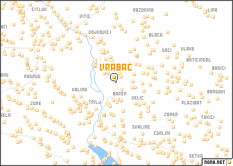
Vrabač (Croatia)Vrabač is a town in Croatia. An overview map of the region around Vrabač is displayed below.
regional and 3d topo map of Vrabač, Croatia ::
Vrabač airports ::
The nearest airport is SPU - Split, located 39.1 km west of Vrabač.
Other airports nearby include OMO - Mostar (97.6 km south east), ZAD - Zadar (123.7 km north west), SJJ - Sarajevo (128.4 km east), DBV - Dubrovnik (173.2 km south east), Nearby towns ::
Udovičić (1.2km north) //
Svinjača (1.2km north east) //
Grab (1.2km south east) //
Bazići (1.6km north) //
Džaja (1.9km north west) //
Žuljovići (2.2km north) //
Bilokapići (2.1km north west) //
Jabuka (2.6km south) //
Matijaševići (2.4km north east) //
Podi (2.0km east) //
Dragani (1.9km east) //
Tadići (2.7km north) //
Zabrde (2.7km south) //
Grgetići (2.6km north west) //
Baren (2.9km south) //
Čosići (2.2km east) //
Krka (3.0km south) //
Ćosići (2.4km north east) //
Jelašci (3.0km north west) //
Ovrlje (3.3km north) //
Gubavica (3.3km south) //
Šipići (3.6km south) //
Katići (3.7km north) //
Bitunjac (3.5km north east) //
Vedrine (3.8km south) //
Vugdelići (3.4km north west) //
Ratkovići (3.1km east) //
Otok (4.1km north) //
Brčići (4.2km north) //
[all distances 'as the bird flies' and approximate]  Places with similar names to Vrabač, Croatia ::
Disclaimer :: Information on this page comes without warranty of any kind |
||
|
Where is Vrabač? Elevation and coordinates ::
Latitude (lat): 43°39'23"N Longitude (lon): 16°45'14"E
Elevation (approx.): 321m (map arrows pan, magnifying glasses zoom) |
||
|
Visiting Vrabač? Hotel/Accommodation ::
Book a hotel in Vrabač Travel Guide ::
Buy a travel guide for Croatia rental cars ::
car rental offers GPS waypoint ::
download a GPX waypoint (PoI) of Vrabač for your GPS receiver
|
||