|
search place name
|
||
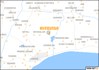
Akrounda (Cyprus)Akrounda is a town in Cyprus. An overview map of the region around Akrounda is displayed below.
regional and 3d topo map of Akrounda, Cyprus ::
Akrounda airports ::
The nearest airport is AKT - Akrotiri, located 21.4 km south west of Akrounda.
Other airports nearby include LCA - Larnaca (51.0 km east), PFO - Paphos Pafos Intl (55.0 km west), HFA - Haifa (283.0 km south east), Nearby towns ::
Phinikaria (2.1km south east) //
Mathikoloni (3.0km west) //
Yermasoyia (5.1km south) //
Moutayiaka (5.3km south) //
Armenokhori (4.8km south east) //
Phasoula (4.9km west) //
Dhierona (6.2km north east) //
Kokkinoyia (6.5km south) //
Ayios Athanasios (6.7km south west) //
Podhimata (7.9km south) //
Ayios Tykhonas (7.1km south east) //
Prastio (7.4km north east) //
Apsiou (7.1km north west) //
Mesayitonia (7.9km south west) //
Ayia Phyla (7.7km south west) //
Parekklisha (7.2km east) //
Spitali (7.2km west) //
Louvaras (8.6km north west) //
Arakapas (8.8km north) //
Palodhia (7.5km west) //
Kellaki (8.8km north east) //
Polemidhia Camp (8.8km south west) //
[all distances 'as the bird flies' and approximate]  Places with similar names to Akrounda, Cyprus ::
// Aguairenda (BO)
// Aguayrenda (BO)
// Akrūnt (OM)
// Acuirindi (MZ)
// Aigurande (FR)
// Agrant (PG)
// Akrund (IN)
Disclaimer :: Information on this page comes without warranty of any kind |
||
|
Where is Akrounda? Elevation and coordinates ::
Latitude (lat): 34°46'0"N Longitude (lon): 33°5'0"E
Elevation (approx.): 157m (map arrows pan, magnifying glasses zoom) |
||
|
Visiting Akrounda? Hotel/Accommodation ::
Book a hotel in Akrounda Travel Guide ::
Buy a travel guide for Cyprus rental cars ::
car rental offers GPS waypoint ::
download a GPX waypoint (PoI) of Akrounda for your GPS receiver
|
||