|
search place name
|
||
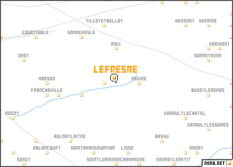
Le Fresne (Champagne-Ardenne, France)Le Fresne is a town in the Champagne-Ardenne region of France. An overview map of the region around Le Fresne is displayed below.
regional and 3d topo map of Le Fresne, France ::
Le Fresne airports ::
The nearest airport is RHE - Reims Champagne, located 61.0 km north west of Le Fresne.
Other airports nearby include QYR - Troyes Barberey (80.2 km south west), MZM - Metz Frescaty (111.0 km east), ETZ - Metz Nancy Lorraine (118.7 km east), ENC - Nancy Essey (119.9 km east), Nearby towns ::
Coupéville (1.2km west) //
Moivre (2.4km east) //
Poix (5.6km north) //
Saint-Jean-sur-Moivre (4.1km south west) //
Somme-Vesle (8.3km north west) //
[all distances 'as the bird flies' and approximate]  Places with similar names to Le Fresne, France ::
// Leversen (DE)
// Laversine (FR)
// La Frasnée (FR)
// La Versanne (FR)
// Le Fresne (FR)
// Laforsen (SE)
// La Fressinie (FR)
// Le Fresnay (FR)
// Le Fresne (FR)
// Le Fresne (FR)
Disclaimer :: Information on this page comes without warranty of any kind |
||
|
Where is Le Fresne? Elevation and coordinates ::
Latitude (lat): 48°55'0"N Longitude (lon): 4°38'0"E
Elevation (approx.): 146m (map arrows pan, magnifying glasses zoom) |
||
|
Visiting Le Fresne? Hotel/Accommodation ::
Book a hotel in Le Fresne Travel Guide ::
Buy a travel guide for France rental cars ::
car rental offers GPS waypoint ::
download a GPX waypoint (PoI) of Le Fresne for your GPS receiver
|
||