|
search place name
|
||
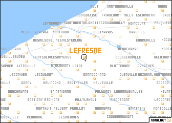
Le Fresne (Haute-Normandie, France)Le Fresne is a town in the Haute-Normandie region of France. An overview map of the region around Le Fresne is displayed below.
regional and 3d topo map of Le Fresne, France ::
Le Fresne airports ::
The nearest airport is LTQ - Le Tourquet Le Touquet Paris Plage, located 59.1 km north of Le Fresne.
Other airports nearby include URO - Rouen Vallee De Seine (71.0 km south), BVA - Beauvais Tille (78.0 km south east), POX - Pontoise Cormeilles En Vexin (109.7 km south east), LEH - Le Havre Octeville (109.9 km south west), Nearby towns ::
Monchy-sur-Eu (1.2km east) //
Baromesnil (2.2km south west) //
Le Tot (2.2km south west) //
Boscrocourt (2.2km north west) //
La Berquerie (2.2km south east) //
Saint-Pierre-en-Val (2.2km north east) //
Beaumont (3.7km north) //
Saint-Rémy-Boscrocourt (3.0km north west) //
Grand Gomard (3.9km south) //
Le Mesnil-Réaume (3.9km south) //
Mesnil-Sterling (4.4km north west) //
Sept-Meules (5.7km south) //
Eu (5.7km north) //
Ponts-et-Marais (5.7km north) //
Heudelimont (4.0km north west) //
Étocquigny (4.0km south west) //
Étalondes (5.1km north west) //
Melleville (6.0km south east) //
Oust-Marais (6.0km north east) //
Saint-Sulpice-sur-Yères (4.8km west) //
Breuilly (4.8km east) //
Saint-Martin-le-Gaillard (5.1km west) //
Villy-le-Bas (7.5km south) //
Saint-Quentin-Lamotte-Croix-au-Bailly (7.5km north) //
Incheville (5.1km east) //
Plattemare (5.1km east) //
Mont-Huon (6.6km north west) //
Flocques (6.0km north west) //
Bouvaincourt-sur-Bresle (6.0km north east) //
[all distances 'as the bird flies' and approximate]  Places with similar names to Le Fresne, France ::
// Leversen (DE)
// Laversine (FR)
// La Frasnée (FR)
// La Versanne (FR)
// Le Fresne (FR)
// Le Fresne (FR)
// Laforsen (SE)
// La Fressinie (FR)
// Le Fresnay (FR)
// Le Fresne (FR)
Disclaimer :: Information on this page comes without warranty of any kind |
||
|
Where is Le Fresne? Elevation and coordinates ::
Latitude (lat): 50°0'0"N Longitude (lon): 1°26'0"E
Elevation (approx.): 107m (map arrows pan, magnifying glasses zoom) |
||
|
Visiting Le Fresne? Hotel/Accommodation ::
Book a hotel in Le Fresne Travel Guide ::
Buy a travel guide for France rental cars ::
car rental offers GPS waypoint ::
download a GPX waypoint (PoI) of Le Fresne for your GPS receiver
|
||