|
search place name
|
||
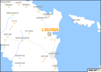
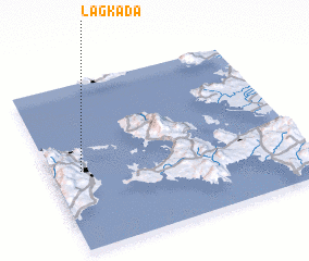
Lagkáda (Chíos, Greece)Lagkáda is a town in the Chíos region of Greece. An overview map of the region around Lagkáda is displayed below.
regional and 3d topo map of Lagkáda, Greece ::
nearby GPS traces from timatio ::
Lagkáda airports ::
The nearest airport is JKH - Chios, located 14.8 km south of Lagkáda.
Other airports nearby include MJT - Mytilini Mitilini (76.7 km north east), IGL - Izmir Cigli (77.7 km east), ADB - Izmir Adnan Menderes (92.8 km east), SMI - Samos (111.5 km south east), Nearby towns ::
 Places with similar names to Lagkáda, Greece ::
// La Coqueta (CO)
// La Coqueta (CO)
// Likokoto (ZM)
// Likokoto (ZM)
// Lukokoda (TZ)
// La Cagüita (VE)
// La Goguette (GP)
// Lugqod (SO)
// Lakai Kota (PK)
// Loccota (AU)
Disclaimer :: Information on this page comes without warranty of any kind |
||
|
Where is Lagkáda? Elevation and coordinates ::
Latitude (lat): 38°28'33"N Longitude (lon): 26°7'15"E
Elevation (approx.): 7m (map arrows pan, magnifying glasses zoom) |
||
|
Visiting Lagkáda? Hotel/Accommodation ::
Book a hotel in Lagkáda Travel Guide ::
Buy a travel guide for Greece rental cars ::
car rental offers GPS waypoint ::
download a GPX waypoint (PoI) of Lagkáda for your GPS receiver
|
||