|
search place name
|
||
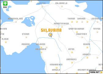
Sklávaina (Piraiévs, Greece)Sklávaina is a town in the Piraiévs region of Greece. An overview map of the region around Sklávaina is displayed below.
regional and 3d topo map of Sklávaina, Greece ::
Sklávaina airports ::
The nearest airport is PVK - Preveza Aktio, located 17.8 km north west of Sklávaina.
Other airports nearby include AGQ - Agrinion (44.7 km south east), EFL - Keffallinia Kefallinia (85.4 km south west), GPA - Patras Araxos (86.2 km south east), IOA - Ioannina (98.0 km north), Nearby towns ::
Kariá (2.3km north west) //
Mesopígadhon (4.0km south) //
Monastirákion (4.7km north east) //
Pálairos (4.7km south west) //
Kalamióna (6.3km south west) //
Vátos (8.0km south east) //
Thírion (8.0km north east) //
[all distances 'as the bird flies' and approximate]  Places with similar names to Sklávaina, Greece ::
// Schlieven (DE)
// Scholven (DE)
// Sklavoúna (GR)
// Sklívani (GR)
// Skilvioniai (LT)
// Skilvioniai (LT)
// Sokolovina (BA)
// Cioclovina (RO)
// Ceclavín (ES)
// Sclafani (IT)
Disclaimer :: Information on this page comes without warranty of any kind |
||
|
Where is Sklávaina? Elevation and coordinates ::
Latitude (lat): 38°49'0"N Longitude (lon): 20°55'0"E
Elevation (approx.): 289m (map arrows pan, magnifying glasses zoom) |
||
|
Visiting Sklávaina? Hotel/Accommodation ::
Book a hotel in Sklávaina Travel Guide ::
Buy a travel guide for Greece rental cars ::
car rental offers GPS waypoint ::
download a GPX waypoint (PoI) of Sklávaina for your GPS receiver
|
||