|
search place name
|
||
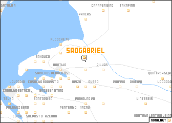
São Gabriel (Setúbal, Portugal)São Gabriel is a town in the Setúbal region of Portugal. An overview map of the region around São Gabriel is displayed below.
regional and 3d topo map of São Gabriel, Portugal ::
São Gabriel airports ::
The nearest airport is LIS - Lisbon Lisboa, located 20.4 km west of São Gabriel.
Other airports nearby include FAO - Faro (206.6 km south east), Nearby towns ::
Atalaia (1.9km south) //
Barroca (2.4km north east) //
Rilvas (3.4km south east) //
Lançada (4.7km south west) //
Carreira (5.6km south) //
Briza (5.7km south) //
São Francisco (4.7km north west) //
Montijo (4.7km south west) //
Russo (5.7km south) //
Alcochete (5.7km north west) //
Sarilhos Grandes (5.7km south west) //
Carregosa (7.1km south west) //
Sarilhos Pequenos (6.9km south west) //
Broegas (8.0km south west) //
Rio Frio (8.0km south east) //
São Sebastião (9.4km south west) //
Moita (9.4km south west) //
[all distances 'as the bird flies' and approximate] 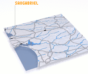 Places with similar names to São Gabriel, Portugal ::
// São Gabriel (BR)
// São Gabriel (BR)
// São Gabriel (BR)
// São Gabriel (BR)
// São Gabriel (BR)
// São Gabriel (PT)
// Sakabariley (GN)
Disclaimer :: Information on this page comes without warranty of any kind |
||
|
Where is São Gabriel? Elevation and coordinates ::
Latitude (lat): 38°43'0"N Longitude (lon): 8°55'0"W
Elevation (approx.): 25m (map arrows pan, magnifying glasses zoom) |
||
|
Visiting São Gabriel? Hotel/Accommodation ::
Book a hotel in São Gabriel Travel Guide ::
Buy a travel guide for Portugal rental cars ::
car rental offers GPS waypoint ::
download a GPX waypoint (PoI) of São Gabriel for your GPS receiver
|
||