|
search place name
|
||
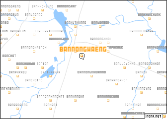
Ban Nong Waeng (Khon Kaen, Thailand)Ban Nong Waeng is a town in the Khon Kaen region of Thailand. An overview map of the region around Ban Nong Waeng is displayed below.
regional and 3d topo map of Ban Nong Waeng, Thailand ::
Ban Nong Waeng airports ::
The nearest airport is UTH - Udon Thani, located 120.3 km north of Ban Nong Waeng.
Other airports nearby include SNO - Sakon Nakhon (170.5 km north east), NAK - Nakhon Ratchasima Khorat (170.6 km south west), LOE - Loei (171.7 km north west), VTE - Vientiane Wattay Intl (188.8 km north), Nearby towns ::
Ban Nong Bua Di Mi (2.6km north west) //
Ban Don Champa (4.1km south east) //
Ban Huai Toei (4.1km south east) //
Ban Nong Khuan Noi (4.1km south east) //
Ban Nong Khoi (5.1km north east) //
Ban Nong Ya Phraek (5.6km east) //
Ban Tha Phra (5.8km north) //
Ban Nong Pho (6.5km north west) //
Ban Don Daeng (6.5km north east) //
Ban Kut Kwang (7.6km north) //
Ban Don Bom (8.2km north east) //
Ban Tha Phra (8.0km south west) //
Ban Wang Phon (9.0km south east) //
Ban Kut Kwang (9.0km north west) //
Changwat Khon Kaen (9.0km north west) //
[all distances 'as the bird flies' and approximate]  Places with similar names to Ban Nong Waeng, Thailand ::
// Ban Nong Waeng (TH)
// Ban Nong Waeng (TH)
// Ban Nong Waeng (TH)
// Ban Nong Waeng (TH)
// Ban Nong Waeng (TH)
// Ban Nong Waeng (TH)
// Ban Nong Waeng (TH)
// Ban Nong Waeng (TH)
// Ban Nong Waeng (TH)
// Ban Nong Waeng (TH)
Disclaimer :: Information on this page comes without warranty of any kind |
||
|
Where is Ban Nong Waeng? Elevation and coordinates ::
Latitude (lat): 16°18'0"N Longitude (lon): 102°49'0"E
Elevation (approx.): 177m (map arrows pan, magnifying glasses zoom) |
||
|
Visiting Ban Nong Waeng? Hotel/Accommodation ::
Book a hotel in Ban Nong Waeng Travel Guide ::
Buy a travel guide for Thailand rental cars ::
car rental offers GPS waypoint ::
download a GPX waypoint (PoI) of Ban Nong Waeng for your GPS receiver
|
||