|
search place name
|
||
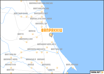
Ban Pak Kiu (Surat Thani, Thailand)Ban Pak Kiu is a town in the Surat Thani region of Thailand. An overview map of the region around Ban Pak Kiu is displayed below.
regional and 3d topo map of Ban Pak Kiu, Thailand ::
Ban Pak Kiu airports ::
The nearest airport is NST - Nakhon Si Thammarat Cha Ian, located 138.8 km south east of Ban Pak Kiu.
Other airports nearby include HKT - Phuket Intl (183.6 km south west), TST - Trang (224.2 km south), Nearby towns ::
Ban Bo Kha (1.9km south) //
Ban Huai Phon Lang (4.1km south west) //
Ban Na Klua (5.2km north west) //
Ban Din Kong (5.5km west) //
Ban Nong Chik (5.9km south) //
Ban Taklop (5.9km south) //
Ban Huai Phon Bon (6.7km south west) //
Ban Khlong Tha Chana (6.7km north west) //
Ban Kiu (7.0km west) //
Ban Nong Mae Kung (7.8km south west) //
Ban Nong Chet (8.3km north west) //
Amphoe Tha Chana (10.4km north west) //
[all distances 'as the bird flies' and approximate]  Places with similar names to Ban Pak Kiu, Thailand ::
// Ban Pak (TH)
// Ban Pak (TH)
// Ban Pak (TH)
// Ban Pa Kae (TH)
// Ban Pa Kao (TH)
// Ban Pa Kao (TH)
// Ban Pa Kia (TH)
// Ban Pak Ka (TH)
// Ban Pak Ko (TH)
// Ban Pa Ko (TH)
Disclaimer :: Information on this page comes without warranty of any kind |
||
|
Where is Ban Pak Kiu? Elevation and coordinates ::
Latitude (lat): 9°30'0"N Longitude (lon): 99°14'0"E
Elevation (approx.): 8m (map arrows pan, magnifying glasses zoom) |
||
|
Visiting Ban Pak Kiu? Hotel/Accommodation ::
Book a hotel in Ban Pak Kiu Travel Guide ::
Buy a travel guide for Thailand rental cars ::
car rental offers GPS waypoint ::
download a GPX waypoint (PoI) of Ban Pak Kiu for your GPS receiver
|
||