|
search place name
|
||
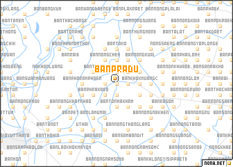
Ban Pradu (Phra Nakhon Si Ayutthaya, Thailand)Ban Pradu is a town in the Phra Nakhon Si Ayutthaya region of Thailand. An overview map of the region around Ban Pradu is displayed below.
regional and 3d topo map of Ban Pradu, Thailand ::
Ban Pradu airports ::
The nearest airport is BKK - Bangkok Intl, located 58.8 km south of Ban Pradu.
Other airports nearby include NAK - Nakhon Ratchasima Khorat (156.8 km east), UTP - Rayong U Taphao Intl (196.5 km south), HHQ - Prachuap Khiri Khan Hua Hin (215.4 km south west), Nearby towns ::
Ban Han Tra (NaNkm north) //
Ban Khok Kham (NaNkm north) //
Ban Wat (1.8km east) //
Ban Pa Phao (1.9km south) //
Phachi (1.9km north) //
Ban Nong Pho (2) (1.8km west) //
Ban Nong Nam Sai (2.6km north east) //
Ban Nong Bet (2.6km south west) //
Ban Khok Muang (2) (3.6km east) //
Ban Khoi Thon (2) (3.7km south) //
Ban Ton Makham (3.7km south) //
Ban Hua Na (3.7km north) //
Ban Tra Nong Nang (4.0km south east) //
Ban Suan Khwan (4.1km south east) //
Ban Nong Pao (4.0km north east) //
Ban Don Ya Nang (4.1km north east) //
Ban Phra Kaeo (4.0km south west) //
Ban Kachiu (4.0km south west) //
Ban Nong Chek (4.1km north west) //
Ban Hua Khung (4.1km north west) //
Ban Tako (4.0km north west) //
Ban Nong Nang (5.2km south east) //
Ban Nong Kuai (5.2km north east) //
Ban Khlong (1) (5.4km east) //
Ban Tako (5.6km north) //
Ban Pho Ramphaen (5.4km west) //
Ban Nong Ngu Luam (5.7km east) //
Ban Don Kok (5.8km north) //
Ban Don Klang (5.7km west) //
[all distances 'as the bird flies' and approximate]  Places with similar names to Ban Pradu, Thailand ::
// Bonaparte (US)
// Ban Ao Pradu (TH)
// Ban Na Pradu (TH)
// Ban Pa Raet (TH)
// Ban Pradao (TH)
// Ban Prado (TH)
// Ban Pradu (TH)
// Ban Pradu (TH)
// Ban Pradu (TH)
// Ban Pradu (TH)
Disclaimer :: Information on this page comes without warranty of any kind |
||
|
Where is Ban Pradu? Elevation and coordinates ::
Latitude (lat): 14°26'0"N Longitude (lon): 100°43'0"E
Elevation (approx.): 5m (map arrows pan, magnifying glasses zoom) |
||
|
Visiting Ban Pradu? Hotel/Accommodation ::
Book a hotel in Ban Pradu Travel Guide ::
Buy a travel guide for Thailand rental cars ::
car rental offers GPS waypoint ::
download a GPX waypoint (PoI) of Ban Pradu for your GPS receiver
|
||