|
search place name
|
||
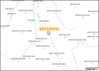
Ban Som Poi (Udon Thani, Thailand)Ban Som Poi is a town in the Udon Thani region of Thailand. An overview map of the region around Ban Som Poi is displayed below.
regional and 3d topo map of Ban Som Poi, Thailand ::
Ban Som Poi airports ::
The nearest airport is UTH - Udon Thani, located 45.5 km east of Ban Som Poi.
Other airports nearby include VTE - Vientiane Wattay Intl (65.6 km north), LOE - Loei (68.0 km west), SNO - Sakon Nakhon (188.5 km east), Nearby towns ::
Ban Kao Kloi (3.5km south west) //
Ban Na Dan (4.8km north west) //
Ban Kut Hu (4.8km north west) //
Ban Nong Saeng (5.3km south west) //
Ban Tan Lian (5.5km east) //
Ban Khop Lek (6.3km south west) //
Ban Nong Bua Noi (7.9km north west) //
Ban Thung Prong (8.0km south) //
Ban Na Di (8.2km north west) //
Ban Nong Waeng (8.6km north) //
Ban Chiang Rai (9.2km north west) //
Ban Nong No (9.7km south east) //
Ban Nong Tae (11.5km south west) //
[all distances 'as the bird flies' and approximate] 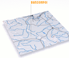 Places with similar names to Ban Som Poi, Thailand ::
// Ban Na Som Poi (TH)
// Ban Som Poi (TH)
// Ban Som Poi (TH)
// Ban Som Poi (TH)
// Ban Som Poi (TH)
// Ban Som Poi (TH)
// Ban Som Poi (TH)
// Ban Som Poi (TH)
// Ban Som Poi (TH)
// Ban Som Poi (TH)
Disclaimer :: Information on this page comes without warranty of any kind |
||
|
Where is Ban Som Poi? Elevation and coordinates ::
Latitude (lat): 17°25'40"N Longitude (lon): 102°21'43"E
Elevation (approx.): 218m (map arrows pan, magnifying glasses zoom) |
||
|
Visiting Ban Som Poi? Hotel/Accommodation ::
Book a hotel in Ban Som Poi Travel Guide ::
Buy a travel guide for Thailand rental cars ::
car rental offers GPS waypoint ::
download a GPX waypoint (PoI) of Ban Som Poi for your GPS receiver
|
||