|
search place name
|
||
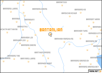
Ban Tan Lian (Udon Thani, Thailand)Ban Tan Lian is a town in the Udon Thani region of Thailand. An overview map of the region around Ban Tan Lian is displayed below.
regional and 3d topo map of Ban Tan Lian, Thailand ::
Ban Tan Lian airports ::
The nearest airport is UTH - Udon Thani, located 40.0 km east of Ban Tan Lian.
Other airports nearby include VTE - Vientiane Wattay Intl (64.6 km north), LOE - Loei (73.5 km west), SNO - Sakon Nakhon (183.0 km east), Nearby towns ::
Ban Khok Nong Kung (5.1km south east) //
Ban Som Poi (5.5km west) //
Ban Huai Siang (7.1km south east) //
Ban Thung Prong (7.6km south) //
Ban Nong No (8.0km south) //
Ban Kao Kloi (8.4km west) //
Ban Nong Saeng (8.8km south west) //
Ban Na Dan (8.9km north west) //
Ban Si Chom Chun (9.8km north east) //
[all distances 'as the bird flies' and approximate] 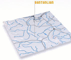 Places with similar names to Ban Tan Lian, Thailand ::
// Ban Don Lan (TH)
// Ban Don Lan (TH)
// Ban Ton Lan (TH)
// Ban Doun-Lan (LA)
// Ban Doun-Lan (LA)
Disclaimer :: Information on this page comes without warranty of any kind |
||
|
Where is Ban Tan Lian? Elevation and coordinates ::
Latitude (lat): 17°25'21"N Longitude (lon): 102°24'50"E
Elevation (approx.): 245m (map arrows pan, magnifying glasses zoom) |
||
|
Visiting Ban Tan Lian? Hotel/Accommodation ::
Book a hotel in Ban Tan Lian Travel Guide ::
Buy a travel guide for Thailand rental cars ::
car rental offers GPS waypoint ::
download a GPX waypoint (PoI) of Ban Tan Lian for your GPS receiver
|
||