|
search place name
|
||
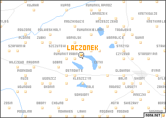
Łączonek (Poland)Łączonek is a town in Poland. An overview map of the region around Łączonek is displayed below.
regional and 3d topo map of Łączonek, Poland ::
Łączonek airports ::
The nearest airport is GDN - Gdansk Lecha Walesy, located 152.5 km north of Łączonek.
Other airports nearby include WAW - Warsaw Okecie (153.4 km south east), KGD - Kaliningrad Khrabrovo (216.5 km north), Nearby towns ::
Trąbin (1.1km west) //
Gulbiny (2.2km north east) //
Rumunki Trąbin (2.2km west) //
Wąpielsk (3.9km north) //
Cetki (2.9km south east) //
Długie (2.9km north east) //
Ostrowite (3.9km south) //
Lisiaki (3.9km south) //
Brzuze (4.3km south west) //
Kleszczyn (5.6km south) //
Rumunki Kiełpiny (5.7km north) //
Szczutowo (3.8km north west) //
Dobre (3.8km south west) //
Borzymin (5.0km south east) //
Piskorczyn (6.0km south) //
Żałe (7.5km south) //
Radziki Duże (7.5km north) //
Półwiesk Wielki (5.8km north west) //
Jakubkowo (5.8km north west) //
Warpalice (5.8km north east) //
Półwiesk Mały (7.1km north west) //
Półwiesk (7.1km north west) //
Wrzeszczewo (8.1km north east) //
Ugoszcz (7.1km south west) //
Nadróż (8.6km south east) //
Okonin (8.6km south west) //
[all distances 'as the bird flies' and approximate] 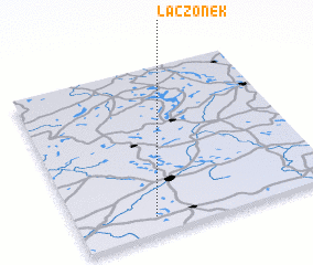 Places with similar names to Łączonek, Poland ::
// La Casanga (PA)
// Łącznik (PL)
// Łucznica (PL)
// Łyczanka (PL)
// Lieke-Asangu (CD)
// Lakh Sang (IR)
// Lacsanga (PE)
// Liuxiang (CN)
// Liuxiang (CN)
// Lạc Sơn (2) (VN)
Disclaimer :: Information on this page comes without warranty of any kind |
||
|
Where is Łączonek? Elevation and coordinates ::
Latitude (lat): 53°6'0"N Longitude (lon): 19°18'0"E
Elevation (approx.): 108m (map arrows pan, magnifying glasses zoom) |
||
|
Visiting Łączonek? Hotel/Accommodation ::
Book a hotel in Łączonek Travel Guide ::
Buy a travel guide for Poland rental cars ::
car rental offers GPS waypoint ::
download a GPX waypoint (PoI) of Łączonek for your GPS receiver
|
||