|
search place name
|
||
Johampolis (Lithuania)Johampolis is a town in Lithuania. An overview map of the region around Johampolis is displayed below.
regional and 3d topo map of Johampolis, Lithuania ::
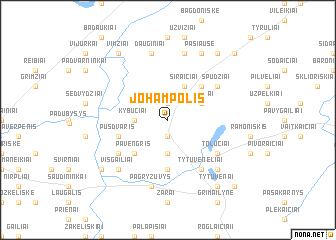
Nearby towns ::
Miežučiai (1.9km north) //
Padurupiai (1.9km north) //
Mockaičiai (1.9km south) //
Kybučiai (2.1km west) //
Gudeliai (3.7km south) //
Peldžiai (2.8km north east) //
Siraičiai (3.9km north) //
Jagminiškė (3.9km north) //
Kiaunoriai (4.3km north east) //
Pavėngris (4.3km south west) //
Kaimalė (5.6km south) //
Pūsdvaris (3.6km south west) //
Kaniūkai (3.6km south west) //
Tytuvėnėliai (5.9km south) //
Paulišiai (4.9km north east) //
Spudžiai (4.9km north east) //
Eimančiai (4.9km south west) //
Tolučiai (4.9km south east) //
Dauginiai (7.5km north) //
Naujamiestis (7.5km north) //
Pagryžuvys (7.5km south) //
Visgailiai (6.4km south west) //
Kubiliai (6.4km south west) //
Kuršiai (6.4km south east) //
Pašiaušė (7.7km north) //
Vimziai (8.0km north west) //
Gudaičiai (8.0km north east) //
Papušynis (7.0km south west) //
Tytuvėnai (8.1km south east) //
[all distances 'as the bird flies' and approximate] 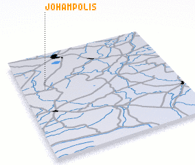 Places with similar names to Johampolis, Lithuania :: Disclaimer :: Information on this page comes without warranty of any kind |
||
|
Where is Johampolis? Elevation and coordinates ::
Latitude (lat): 55°40'0"N Longitude (lon): 23°9'0"E
Elevation (approx.): 129m (map arrows pan, magnifying glasses zoom) |
||
|
Visiting Johampolis? Hotel/Accommodation ::
Book a hotel in Johampolis Travel Guide ::
Buy a travel guide for Lithuania rental cars ::
car rental offers GPS waypoint ::
download a GPX waypoint (PoI) of Johampolis for your GPS receiver
|
||