|
search place name
|
||
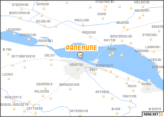
Panemunė (Lithuania)Panemunė is a town in Lithuania. An overview map of the region around Panemunė is displayed below.
regional and 3d topo map of Panemunė, Lithuania ::
Panemunė airports ::
The nearest airport is KGD - Kaliningrad Khrabrovo, located 86.2 km west of Panemunė.
Nearby towns ::
Plaušvarė (2.0km north) //
Sovetsk (2.5km south) //
Sady (3.9km south east) //
Pagėgiai (5.1km north) //
Pionerskiy (4.1km south east) //
Prūseliai (3.8km east) //
(( Petrovo )) (4.8km south east) //
Dal'niy (4.1km west) //
Mikytai (4.9km north east) //
Šokai (4.3km east) //
Ippodrom (4.3km west) //
Barsukovka (7.2km south) //
Pavilkiai (7.8km north) //
Nausėdai (5.6km north west) //
Dubki (6.1km south east) //
Anužiai (8.1km north west) //
Petrovo (9.0km south) //
Govorovo (8.4km south west) //
Šilgaliai (9.0km north west) //
[all distances 'as the bird flies' and approximate] 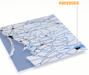 Places with similar names to Panemunė, Lithuania ::
Disclaimer :: Information on this page comes without warranty of any kind |
||
|
Where is Panemunė? Elevation and coordinates ::
Latitude (lat): 55°5'36"N Longitude (lon): 21°53'31"E
Elevation (approx.): 5m (map arrows pan, magnifying glasses zoom) |
||
|
Visiting Panemunė? Hotel/Accommodation ::
Book a hotel in Panemunė Travel Guide ::
Buy a travel guide for Lithuania rental cars ::
car rental offers GPS waypoint ::
download a GPX waypoint (PoI) of Panemunė for your GPS receiver
|
||