|
search place name
|
||
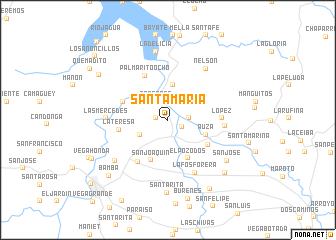
Santa María (Santiago de Cuba, Cuba)Santa María is a town in the Santiago de Cuba region of Cuba. An overview map of the region around Santa María is displayed below.
regional and 3d topo map of Santa María, Cuba ::
Santa María airports ::
The nearest airport is SCU - Santiago De Cuba Antonio Maceo Intl, located 35.7 km south of Santa María.
Other airports nearby include HOG - Holguin Frank Pais Intl (69.3 km north west), BYM - Bayamo Carlos Manuel De Cespedes (74.2 km west), GAO - Guantanamo Mariana Grajales (82.7 km east), MOA - Moa Orestes Acosta (112.1 km east), Nearby towns ::
Oros (1.3km west) //
Monte Dos Leguas (1.6km south east) //
San Nicolás (2.1km north) //
San Nicolás (2.2km east) //
Trocones (2.4km north west) //
Cabrera (3.4km south west) //
Palmarito del Cauto (3.9km north) //
Auza (4.3km south east) //
El Pozo Dos (4.8km south east) //
San Joaquín (4.8km south) //
Chile (5.1km south east) //
Andrés Vaillant (5.1km north west) //
La Teresa (5.2km west) //
Palmarito Ocho (5.5km north west) //
Alambre (5.7km south west) //
López (5.7km east) //
Santa Isabel (6.0km east) //
La Fosforera (6.5km south east) //
Las Mercedes (6.5km west) //
Nelson (7.0km north east) //
La Luisa (7.2km south west) //
La Delicia (7.7km north) //
San José (7.7km south east) //
Santa Rita (8.1km south) //
Dagame (8.4km south east) //
Capitán de España (8.9km south east) //
Bamba (8.8km south west) //
Burenes (9.0km south) //
Quemadito (8.8km north west) //
[all distances 'as the bird flies' and approximate]  Places with similar names to Santa María, Cuba ::
// Santa Maria (BR)
// Santa Maria (BR)
// Santa Maria (BR)
// Santa Maria (BR)
// Santa Maria (BR)
// Santa Maria (BR)
// Santa Maria (BR)
// Santa Maria (BR)
// Santa Maria (BR)
// Santa Maria (BR)
Disclaimer :: Information on this page comes without warranty of any kind |
||
|
Where is Santa María? Elevation and coordinates ::
Latitude (lat): 20°16'54"N Longitude (lon): 75°55'17"W
Elevation (approx.): 133m (map arrows pan, magnifying glasses zoom) |
||
|
Visiting Santa María? Hotel/Accommodation ::
Book a hotel in Santa María Travel Guide ::
Buy a travel guide for Cuba rental cars ::
car rental offers GPS waypoint ::
download a GPX waypoint (PoI) of Santa María for your GPS receiver
|
||