|
search place name
|
||
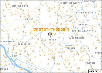
‘Izbat ath Thamānīn (Kafr ash Shaykh, Egypt)‘Izbat ath Thamānīn is a town in the Kafr ash Shaykh region of Egypt. An overview map of the region around ‘Izbat ath Thamānīn is displayed below.
regional and 3d topo map of ‘Izbat ath Thamānīn, Egypt ::
‘Izbat ath Thamānīn airports ::
The nearest airport is ALY - Alexandria Intl, located 77.8 km west of ‘Izbat ath Thamānīn.
Other airports nearby include CAI - Cairo Intl (134.9 km south east), PSD - Port Said (140.7 km east), Nearby towns ::
‘Izbat al Kurdāwī (0.6km north east) //
‘Izbat as Sayyid Aḩmad as Samādūnī (1.2km north) //
‘Izbat Abū al ‘Aynayn (1.5km north east) //
‘Izbat Mūsá Ḩusayn (2.1km north east) //
‘Izbat ash Shūkah (2.3km south) //
Shābah (2.4km south) //
‘Izbat al Bāz (2.3km south west) //
‘Izbat al Işlāḩ (2.5km east) //
‘Izbat ad Duktūr Muḩammad ‘Abd al Khāliq (3.2km south) //
‘Izbat Abū ‘Īţah (3.5km north east) //
Kawm Buţū (3.2km south west) //
‘Izbat Abū Zahrah (3.7km north east) //
Kafr ‘Alī Abū Ziyādah (3.7km south east) //
Ibţū (3.6km south west) //
‘Izbat al ‘Abd (4.2km north) //
‘Izbat al ‘Umdah (3.9km north east) //
‘Izbat Khalīl al Qaşşāş (4.2km south west) //
‘Izbat ar Rubā‘īyah (3.8km east) //
‘Izbat an Nawāyijah (4.2km north west) //
‘Izbat Sayyid Sa‘fān (4.0km north east) //
‘Izbat ‘Azmī ‘Āshūr (4.6km north) //
‘Izbat Nuwaysh (4.2km south east) //
‘Izbat Muḩarram (4.1km west) //
‘Izbat Fuʼād Rajab (4.8km south) //
Ash Shuwan (4.9km south) //
Al ‘Ajūzayn (4.9km south) //
‘Izbat ‘Abd al Jawwād ‘Ilaywah (4.5km north east) //
Barrīyat al ‘Ajūzayn (5.2km north) //
‘Izbat Ghunaym (4.6km west) //
[all distances 'as the bird flies' and approximate]  Places with similar names to ‘Izbat ath Thamānīn, Egypt ::
// ‘Izbat ath Thamānīn (EG)
// ‘Izbat ath Thamānīn (EG)
Disclaimer :: Information on this page comes without warranty of any kind |
||
|
Where is ‘Izbat ath Thamānīn? Elevation and coordinates ::
Latitude (lat): 31°12'20"N Longitude (lon): 30°45'55"E
Elevation (approx.): 2m (map arrows pan, magnifying glasses zoom) |
||
|
Visiting ‘Izbat ath Thamānīn? Hotel/Accommodation ::
Book a hotel in ‘Izbat ath Thamānīn Travel Guide ::
Buy a travel guide for Egypt rental cars ::
car rental offers GPS waypoint ::
download a GPX waypoint (PoI) of ‘Izbat ath Thamānīn for your GPS receiver
|
||