|
search place name
|
||
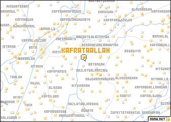
Kafr ‘Aţāʼ Allāh (Al Qalyūbīyah, Egypt)Kafr ‘Aţāʼ Allāh is a town in the Al Qalyūbīyah region of Egypt. An overview map of the region around Kafr ‘Aţāʼ Allāh is displayed below.
regional and 3d topo map of Kafr ‘Aţāʼ Allāh, Egypt ::
Kafr ‘Aţāʼ Allāh airports ::
The nearest airport is CAI - Cairo Intl, located 37.9 km south of Kafr ‘Aţāʼ Allāh.
Other airports nearby include PSD - Port Said (131.1 km north east), ALY - Alexandria Intl (150.8 km north west), Nearby towns ::
Kafr ash Shaykh Ibrāhīm (1.2km south) //
Kafr Abū Zahrah (2.1km west) //
Quţayyifat al ‘Azīzīyah (2.6km north) //
Batamdah (2.7km south east) //
‘Izbat Kafr al Ḩamām (2.8km west) //
Minshāt Dhiʼāb (3.2km south) //
Nazlat Salmān Zāʼid (3.2km south) //
Kafr ash Sha‘āwirah (2.9km east) //
Shiblanjah (3.4km north) //
‘Izbat Muḩammad Bāshāt (3.2km south west) //
Aş Şanāfīn al Qiblīyah (3.1km east) //
Jazīrat Billī (3.6km south east) //
Aş Şanāfīn al Baḩrīyah (3.8km north east) //
Nuqbās (3.8km west) //
Nazlat as Sibā‘āt (4.1km south east) //
Nazlat ‘Awdah Ḩammūd (4.1km south east) //
Barqaţā (4.5km north) //
Al Majāzir (4.2km south east) //
Marsafa (4.5km south west) //
Minyat as Sibā‘ (4.3km west) //
‘Izbat ‘llaysh (4.6km south west) //
Banī Ḩusayn (4.5km east) //
Kafr ash Shimūt (4.5km west) //
Sanhūt al Birak (4.7km north east) //
Qamrūnah (5.3km north east) //
Al ‘Azīzīyah (5.3km north east) //
Naj‘ Ghānim Abū Raʼs (5.6km south east) //
‘Arab al Muqābilah (5.6km south east) //
Nazlat Buşaylān (5.6km south east) //
[all distances 'as the bird flies' and approximate]  Places with similar names to Kafr ‘Aţāʼ Allāh, Egypt ::
Disclaimer :: Information on this page comes without warranty of any kind |
||
|
Where is Kafr ‘Aţāʼ Allāh? Elevation and coordinates ::
Latitude (lat): 30°26'36"N Longitude (lon): 31°16'14"E
Elevation (approx.): 12m (map arrows pan, magnifying glasses zoom) |
||
|
Visiting Kafr ‘Aţāʼ Allāh? Hotel/Accommodation ::
Book a hotel in Kafr ‘Aţāʼ Allāh Travel Guide ::
Buy a travel guide for Egypt rental cars ::
car rental offers GPS waypoint ::
download a GPX waypoint (PoI) of Kafr ‘Aţāʼ Allāh for your GPS receiver
|
||