|
search place name
|
||
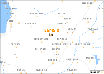
Eşmişik (Hatay, Turkey)Eşmişik is a town in the Hatay region of Turkey. An overview map of the region around Eşmişik is displayed below.
regional and 3d topo map of Eşmişik, Turkey ::
Eşmişik airports ::
The nearest airport is ALP - Aleppo Intl, located 90.3 km south east of Eşmişik.
Other airports nearby include ADA - Adana Incirlik Ab (94.7 km north west), ADA - Adana (105.2 km north west), GZT - Gaziantep Oguzeli (108.6 km east), LTK - Latakia Bassel Al Assad Intl (136.1 km south), Nearby towns ::
Ceyhanlı (3.5km south east) //
Değirmendere (3.5km south west) //
Karataş (4.0km south) //
Güzelce (4.8km north east) //
Alabeyli (5.8km south) //
Alibeyçağılı (4.8km north east) //
Delibekirli (6.3km south west) //
Kodallı (5.8km south east) //
İçada (7.6km south) //
Abalaklı (6.2km east) //
Çamsarı (6.2km east) //
Taşoluk (7.1km north east) //
Saylak (8.0km north) //
Demircidibi (7.0km north west) //
Değirmendere (8.7km north west) //
[all distances 'as the bird flies' and approximate] 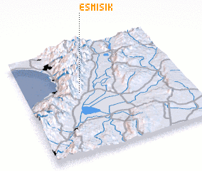 Places with similar names to Eşmişik, Turkey :: Disclaimer :: Information on this page comes without warranty of any kind |
||
|
Where is Eşmişik? Elevation and coordinates ::
Latitude (lat): 36°35'0"N Longitude (lon): 36°21'0"E
Elevation (approx.): 861m (map arrows pan, magnifying glasses zoom) |
||
|
Visiting Eşmişik? Hotel/Accommodation ::
Book a hotel in Eşmişik Travel Guide ::
Buy a travel guide for Turkey rental cars ::
car rental offers GPS waypoint ::
download a GPX waypoint (PoI) of Eşmişik for your GPS receiver
|
||