|
search place name
|
||
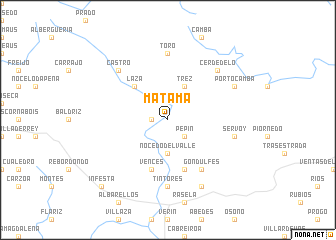
Matamá (Galicia, Spain)Matamá is a town in the Galicia region of Spain. An overview map of the region around Matamá is displayed below.
regional and 3d topo map of Matamá, Spain ::
Matamá airports ::
The nearest airport is BGC - Braganca, located 63.3 km east of Matamá.
Other airports nearby include VRL - Vila Real (87.6 km south), VGO - Vigo (101.1 km west), SCQ - Santiago (125.3 km north west), OPO - Porto (135.7 km south west), Nearby towns ::
Retorta (1.4km west) //
Pepín (2.3km south east) //
Nocedo del Valle (3.7km south) //
Trez (4.0km north) //
Laza (4.6km north west) //
Castrelo del Valle (5.7km south) //
Estevesiños (5.7km south) //
Vences (5.7km south) //
Gondulfes (6.2km south east) //
Tintores (7.4km south) //
Toro (7.4km north) //
Servoy (5.8km east) //
Cerdedelo (6.9km north east) //
Castro (6.9km north west) //
Quiroganes (7.9km south) //
Portocamba (6.6km north east) //
Infesta (9.2km south west) //
[all distances 'as the bird flies' and approximate]  Places with similar names to Matamá, Spain ::
Disclaimer :: Information on this page comes without warranty of any kind |
||
|
Where is Matamá? Elevation and coordinates ::
Latitude (lat): 42°2'0"N Longitude (lon): 7°26'0"W
Elevation (approx.): 470m (map arrows pan, magnifying glasses zoom) |
||
|
Visiting Matamá? Hotel/Accommodation ::
Book a hotel in Matamá Travel Guide ::
Buy a travel guide for Spain rental cars ::
car rental offers GPS waypoint ::
download a GPX waypoint (PoI) of Matamá for your GPS receiver
|
||