|
search place name
|
||
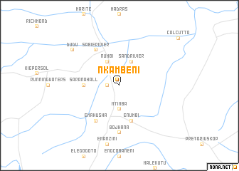
Nkambeni (South Africa)Nkambeni is a town in South Africa. An overview map of the region around Nkambeni is displayed below.
regional and 3d topo map of Nkambeni, South Africa ::
Nkambeni airports ::
The nearest airport is SZK - Skukuza, located 46.3 km east of Nkambeni.
Other airports nearby include HDS - Hoedspruit Afb (79.8 km north), PHW - Phalaborwa (127.0 km north), MTS - Manzini Matsapha (160.9 km south), LTA - Tzaneen (162.4 km north west), Nearby towns ::
Bongani (1.7km west) //
Mtimba (3.7km south) //
Numbi (4.1km north west) //
Sandrivier (4.1km north east) //
Sarana Hall (5.0km west) //
eNumbi (5.8km south) //
Hazyview (6.5km north west) //
eMahusha (6.5km south west) //
Sabierivier (6.5km north west) //
Bojwana (7.4km south) //
Dudu (8.7km north west) //
[all distances 'as the bird flies' and approximate] 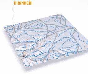 Places with similar names to Nkambeni, South Africa ::
// Ngamin (MM)
// Ngomuin (CM)
// Ngomban (CM)
// Nowy Kamień (PL)
// Na Kamenu (BA)
// Ngomani II (TD)
// Nekmaneo (ID)
// Ngambon (ID)
// Nikoman (MK)
// Ngombani (KE)
Disclaimer :: Information on this page comes without warranty of any kind |
||
|
Where is Nkambeni? Elevation and coordinates ::
Latitude (lat): 25°5'0"S Longitude (lon): 31°9'0"E
Elevation (approx.): 552m (map arrows pan, magnifying glasses zoom) |
||
|
Visiting Nkambeni? Hotel/Accommodation ::
Book a hotel in Nkambeni Travel Guide ::
rental cars ::
car rental offers GPS waypoint ::
download a GPX waypoint (PoI) of Nkambeni for your GPS receiver
|
||