|
search place name
|
||
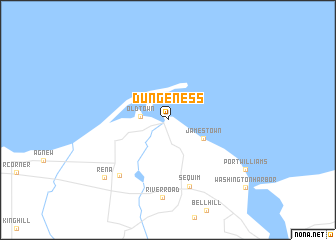
Dungeness (Washington, United States - USA)Dungeness is a town in the Washington region of United States - USA. An overview map of the region around Dungeness is displayed below.
regional and 3d topo map of Dungeness, United States - USA ::
Dungeness airports ::
The nearest airport is YYJ - Victoria Intl, located 60.0 km north of Dungeness.
Other airports nearby include PAE - Everett Snohomish Co (68.2 km south east), BLI - Bellingham Intl (83.8 km north east), BFI - Seattle Boeing Fld King Co Intl (92.0 km south east), SEA - Seattle Tacoma Intl (98.6 km south east), Nearby towns ::
Old Town (2.1km west) //
Jamestown (3.4km south east) //
Sequim (7.6km south) //
Carlsborg (7.2km south west) //
River Road (8.7km south) //
Rena (7.9km south west) //
Port Williams (8.0km south east) //
Washington Harbor (9.5km south east) //
[all distances 'as the bird flies' and approximate] 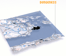 Places with similar names to Dungeness, United States - USA ::
// Taung-inzu (MM)
// Dungeness (US)
// Tinajones (PA)
// Tangenes (NO)
// Tinajones (PE)
// Tinajones (PE)
// Tinajones (PE)
// Tinajones (PE)
// Donji Anići (HR)
Disclaimer :: Information on this page comes without warranty of any kind |
||
|
Where is Dungeness? Elevation and coordinates ::
Latitude (lat): 48°8'49"N Longitude (lon): 123°7'19"W
Elevation (approx.): 3m (map arrows pan, magnifying glasses zoom) |
||
|
Visiting Dungeness? Hotel/Accommodation ::
Book a hotel in Dungeness Travel Guide ::
rental cars ::
car rental offers GPS waypoint ::
download a GPX waypoint (PoI) of Dungeness for your GPS receiver
|
||