|
search place name
|
||
Cam Co Ram (Thanh Hóa, Vietnam)Cam Co Ram is a town in the Thanh Hóa region of Vietnam. An overview map of the region around Cam Co Ram is displayed below.
regional and 3d topo map of Cam Co Ram, Vietnam ::

Cam Co Ram airports ::
The nearest airport is HAN - Hanoi Noibai Intl, located 127.3 km north of Cam Co Ram.
Nearby towns ::
Cam Trong (1.7km east) //
Cam Ràm (1.7km west) //
Thủy Thanh (2.5km south east) //
Chòm Ngu (3.7km north) //
Án Ðo18 (4.1km north west) //
Ngọc Diền (3.9km north west) //
Làng Ro (3.9km south west) //
An Cư (5.1km south east) //
Lộc Thịnh (5.1km south east) //
Làng Giót (5.6km south) //
Vô Ky (5.5km east) //
Làng Bùi (5.8km south) //
Làng Toùng (5.8km north) //
Cam Ruong (5.5km west) //
Chòm Ngọc (6.4km north east) //
Chòm Co Giều (6.4km south east) //
Chòm Hơi (6.6km north west) //
Chòm Nia (7.4km north) //
Chòm Do (7.2km east) //
Cam Mun (7.6km north) //
Quan Bằng (7.2km east) //
Làng Su (7.2km west) //
Làng Mòn (7.6km south) //
Chòm Cò (7.6km north east) //
Mông Sơn (7.6km south west) //
Tử Nê (7.9km south east) //
Kim Hạ (8.9km north east) //
Quan Trì (10.2km south east) //
Làng Mót (10.2km south west) //
[all distances 'as the bird flies' and approximate] 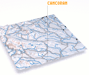 Places with similar names to Cam Co Ram, Vietnam ::
Disclaimer :: Information on this page comes without warranty of any kind |
||
|
Where is Cam Co Ram? Elevation and coordinates ::
Latitude (lat): 20°7'0"N Longitude (lon): 105°28'0"E
Elevation (approx.): 114m (map arrows pan, magnifying glasses zoom) |
||
|
Visiting Cam Co Ram? Hotel/Accommodation ::
Book a hotel in Cam Co Ram Travel Guide ::
Buy a travel guide for Vietnam rental cars ::
car rental offers GPS waypoint ::
download a GPX waypoint (PoI) of Cam Co Ram for your GPS receiver
|
||