|
search place name
|
||
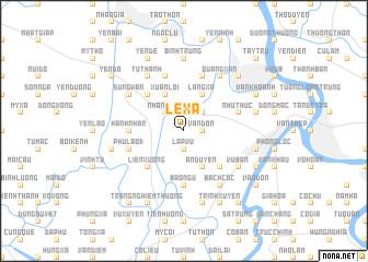
Lê Xá (Vietnam)Lê Xá is a town in Vietnam. An overview map of the region around Lê Xá is displayed below.
regional and 3d topo map of Lê Xá, Vietnam ::
Lê Xá airports ::
The nearest airport is HAN - Hanoi Noibai Intl, located 92.4 km north of Lê Xá.
Nearby towns ::
Lập Vũ (1.9km south) //
Bến Thôn (1.9km south) //
Ðộ Viêt (1.9km north) //
Vạn Ðồn (1.7km east) //
Nhân Nhuế (2.5km north west) //
Ðặng Xá (2.5km north east) //
An Duyên (4.1km south east) //
Xuân Lôi (4.1km north west) //
Lang Xá (4.1km north east) //
Liên Xương (5.1km south west) //
Mai Xá (2) (5.1km south east) //
Khê Cầu (5.1km north west) //
Hành Nhân (5.2km west) //
Bảo Ngũ (5.6km south) //
Phú Lão (1) (5.5km west) //
Tiên Khoán (5.8km north) //
Thành Th (5.8km north) //
Nguyễn Xá (5.8km north) //
Như Thức (5.5km east) //
Tử Thanh (6.6km north west) //
Bách Cốc (6.6km south east) //
Quang Xán (6.6km north east) //
Vu Bản (6.4km south east) //
Sùng Văn (6.4km north west) //
Cao Dương (6.4km north west) //
Bỉnh Trung (7.4km north) //
Ðắc Lực (7.6km south) //
Duyên Trường (7.2km west) //
Mỹ Trọng (7.2km east) //
[all distances 'as the bird flies' and approximate]  Places with similar names to Lê Xá, Vietnam ::
Disclaimer :: Information on this page comes without warranty of any kind |
||
|
Where is Lê Xá? Elevation and coordinates ::
Latitude (lat): 20°26'0"N Longitude (lon): 106°6'0"E
Elevation (approx.): 3m (map arrows pan, magnifying glasses zoom) |
||
|
Visiting Lê Xá? Hotel/Accommodation ::
Book a hotel in Lê Xá Travel Guide ::
Buy a travel guide for Vietnam rental cars ::
car rental offers GPS waypoint ::
download a GPX waypoint (PoI) of Lê Xá for your GPS receiver
|
||