|
search place name
|
||
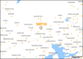
Santui (Zhejiang, China)Santui is a town in the Zhejiang region of China. An overview map of the region around Santui is displayed below.
regional and 3d topo map of Santui, China ::
Santui airports ::
The nearest airport is NGB - Ninbo Lishe, located 156.1 km north of Santui.
Other airports nearby include HGH - Hangzhou Xiaoshan (208.4 km north), Nearby towns ::
Pingyuan (1.7km south west) //
Changyang (2.5km north west) //
Shuangfeng (3.1km south) //
Longbi'ao (3.2km south) //
Donglin (3.3km east) //
Lizhaiji (3.4km east) //
Xia'ao (4.2km north) //
Shitan (4.0km north east) //
Xixin (4.0km west) //
Dayuan (4.2km south east) //
Dajingtou (5.1km north) //
Yanggu'ao (5.1km north) //
Xiayutan (5.1km south) //
Dajingzhen (5.3km south east) //
Yandong (5.7km south) //
Jiufang (5.8km south) //
Yejiayang (5.2km west) //
Xianxizhen (7.1km south west) //
Shuizhang (7.6km south east) //
Xiabeige (7.3km south west) //
Liqiao (7.1km east) //
Chengzhaixia (7.7km south east) //
Zhuonan (7.6km south west) //
Taolin (7.7km south west) //
Tianchakeng (7.3km east) //
Shanxiakeng (7.7km north east) //
Yandangshan (8.6km south) //
Xianglingtou (8.8km south) //
Jingzhu (9.1km north east) //
[all distances 'as the bird flies' and approximate]  Places with similar names to Santui, China ::
Disclaimer :: Information on this page comes without warranty of any kind |
||
|
Where is Santui? Elevation and coordinates ::
Latitude (lat): 28°26'59"N Longitude (lon): 121°7'36"E
Elevation (approx.): 38m (map arrows pan, magnifying glasses zoom) |
||
|
Visiting Santui? Hotel/Accommodation ::
Book a hotel in Santui Travel Guide ::
Buy a travel guide for China rental cars ::
car rental offers GPS waypoint ::
download a GPX waypoint (PoI) of Santui for your GPS receiver
|
||