|
search place name
|
||
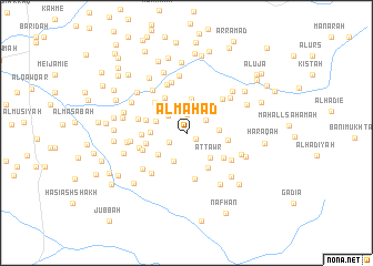
Al Mahad (Al Ḩudaydah, Yemen)Al Mahad is a town in the Al Ḩudaydah region of Yemen. An overview map of the region around Al Mahad is displayed below.
regional and 3d topo map of Al Mahad, Yemen ::
Nearby towns ::
Aş Şa‘īd (1.1km south east) //
Ḩājir (1.9km north) //
Al Fuqayhīyah (1.9km south west) //
Al Mulayţah (2.3km north east) //
Al Marāwigh (2.5km north west) //
Al Judūr (2.6km north) //
Al Qāḑiyah (3.1km south west) //
Dayr Umm Şa‘d (3.2km west) //
Al Jabīl (3.2km east) //
Al Jurmūdīyah (3.4km north) //
Aţ Ţawr (3.5km south east) //
Al Ḩakāmīyah (3.5km north west) //
Dayr al Qāşir (3.5km west) //
Ḩasy al Maqbūlī (3.5km south west) //
Ad Dumaynah (4.1km north west) //
Buyūt Umm Baba‘īyah (4.1km south east) //
Şanīf ‘Abd Allāh ‘Umar (4.1km west) //
Al Wisāyah (4.1km west) //
Ad Dimnah (4.1km east) //
Buyūt al Ma‘arīf (4.3km north west) //
Al Marāmīd (4.3km west) //
Al Qufl (4.4km south east) //
Umm Umayrīyah (4.6km west) //
Al Kirnah (4.7km south) //
Kūz (4.9km north east) //
Buyūt ad Darāḩimah (4.9km west) //
Ash Sharīfīyah (4.9km west) //
Al Majrab (5.2km north) //
Al ‘Ayrīyah (5.3km north) //
[all distances 'as the bird flies' and approximate]  Places with similar names to Al Mahad, Yemen ::
// Al Muḩawwaţah (IQ)
// Al Maḩaţţah (LB)
// Al Maḩaţţah (SA)
// Al Maḩaţţah (JO)
// Al Maḩaţţah (OM)
// Al Maḩadah (YE)
// Al Maḩaţţah (LB)
// Al Maḩaţţah (LB)
// Al Maḩaţţah (LB)
// Al Maḩaţţah (YE)
Disclaimer :: Information on this page comes without warranty of any kind |
||
|
Where is Al Mahad? Elevation and coordinates ::
Latitude (lat): 14°32'49"N Longitude (lon): 43°27'10"E
Elevation (approx.): 204m (map arrows pan, magnifying glasses zoom) |
||
|
Visiting Al Mahad? Hotel/Accommodation ::
Book a hotel in Al Mahad Travel Guide ::
Buy a travel guide for Yemen rental cars ::
car rental offers GPS waypoint ::
download a GPX waypoint (PoI) of Al Mahad for your GPS receiver
|
||