|
search place name
|
||
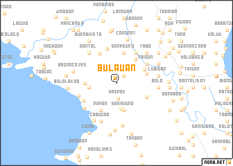
Bulauan (Camarines Sur, Philippines)Bulauan is a town in the Camarines Sur region of Philippines. An overview map of the region around Bulauan is displayed below.
regional and 3d topo map of Bulauan, Philippines ::
Bulauan airports ::
The nearest airport is MNL - Manila Ninoy Aquino Intl, located 218.4 km north west of Bulauan.
Nearby towns ::
Bonacan (1.6km north east) //
Maspok (2.6km south) //
Danggaya (4.3km south) //
Cabutagan (4.2km north east) //
Tapi (4.2km north east) //
Cansabel (4.3km west) //
San Isidro (4.5km south) //
Lupi (4.9km north east) //
San Pedro (5.0km north) //
Manangle (4.9km north east) //
Amahit (4.9km west) //
Bulawan (4.9km east) //
Pipian (5.0km south west) //
Lubigan (5.2km south east) //
San Rafael (5.4km north west) //
Salvacion (5.7km north) //
Taisan (5.6km north east) //
Bagagñan (5.7km north east) //
Pigbasagan (5.7km north east) //
Ihit (5.9km south west) //
Bagñon (6.2km west) //
Santol (6.5km north west) //
Tagbac (6.5km south west) //
Cabugao (6.7km south) //
Bolo (6.6km east) //
Lubigan (6.6km east) //
Yabo (6.8km north east) //
Caibigan (6.8km north east) //
Bagacay (7.0km south) //
[all distances 'as the bird flies' and approximate] 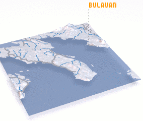 Places with similar names to Bulauan, Philippines ::
Disclaimer :: Information on this page comes without warranty of any kind |
||
|
Where is Bulauan? Elevation and coordinates ::
Latitude (lat): 13°45'22"N Longitude (lon): 122°53'22"E
Elevation (approx.): 55m (map arrows pan, magnifying glasses zoom) |
||
|
Visiting Bulauan? Hotel/Accommodation ::
Book a hotel in Bulauan Travel Guide ::
Buy a travel guide for Philippines rental cars ::
car rental offers GPS waypoint ::
download a GPX waypoint (PoI) of Bulauan for your GPS receiver
|
||