|
search place name
|
||
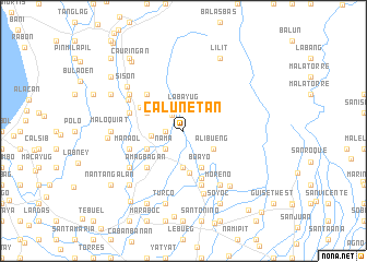
Calunetan (Pangasinan, Philippines)Calunetan is a town in the Pangasinan region of Philippines. An overview map of the region around Calunetan is displayed below.
regional and 3d topo map of Calunetan, Philippines ::
Calunetan airports ::
The nearest airport is BAG - Baguio, located 27.3 km north of Calunetan.
Other airports nearby include MNL - Manila Ninoy Aquino Intl (186.2 km south), Nearby towns ::
Villegas (1.8km west) //
Sugcong (2.0km north west) //
Labayug (2.4km north) //
Imbalbalatong (2.6km south west) //
Nantangalan (2.6km south west) //
Nama (2.6km south west) //
Cablong (2.6km south west) //
Inoman (2.6km south west) //
Palacpalac (3.2km west) //
Alibueng (3.5km south east) //
Alipangpang (3.7km south) //
Boayo (4.1km south east) //
Amaling (4.0km south west) //
Paldit (4.0km north west) //
Rosario (4.3km south) //
Bataquil (4.8km north west) //
Talogtog (5.1km south west) //
Amagbagan (5.1km south west) //
Paldit (5.1km north west) //
Bugayong (5.2km south) //
Manaol (5.7km west) //
Palguyod (5.7km west) //
Dumayat (5.8km south) //
Asan Sur (5.7km west) //
Bobonan (5.7km west) //
Alava (6.3km north west) //
Tulnac (6.5km south west) //
Dagupan (6.5km south west) //
Linmayao (6.6km south east) //
[all distances 'as the bird flies' and approximate] 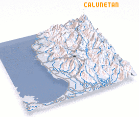 Places with similar names to Calunetan, Philippines ::
// Cline Town (SL)
// Calanutan (PH)
// Calinta-an (PH)
// Calintaan (PH)
// Calintaan (PH)
// Calintaan (PH)
// Kaliantana (PH)
// Clanton (US)
// Clinton (US)
// Kleinotten (AT)
Disclaimer :: Information on this page comes without warranty of any kind |
||
|
Where is Calunetan? Elevation and coordinates ::
Latitude (lat): 16°8'0"N Longitude (lon): 120°34'0"E
Elevation (approx.): 80m (map arrows pan, magnifying glasses zoom) |
||
|
Visiting Calunetan? Hotel/Accommodation ::
Book a hotel in Calunetan Travel Guide ::
Buy a travel guide for Philippines rental cars ::
car rental offers GPS waypoint ::
download a GPX waypoint (PoI) of Calunetan for your GPS receiver
|
||